Originally published by Rhonda Brooks on Farm Journal Magazine. Re-published with permission from the author in its entirety.
From Wiki Commons
“Wind and hail took a big yield bite out of one of Mason Lantrip’s cornfields last summer. When the insurance adjuster showed up to verify the claim the two men enlisted help to assess the damage in the tall, tasseled corn, from Lantrip’s unmanned aerial vehicle (UAV or drone).
“He said ‘Fly it to your four worst spots.’ So, I flew the drone over the field and hovered it. He walked to the drone and came back and said, ‘Oh, it’s really bad in there,’” recalls Lantrip, who farms near Coatesville, Ind.
Ultimately, Lantrip says his insurance paid nearly twice the amount he initially expected for the corn wind damage, and that wasn’t the first time the drone, a quadcopter, improved his bottom line.
“You know, it’s paid for itself 10 to 20 times over, and it’s done that three or four different years,” Lantrip says.
When UAVs entered the ag marketplace, they did so with considerable fanfare. But today, only 31% of U.S. farmers say they find value in using a drone. Forty percent of farmers don’t use one and don’t plan to, according to a March Pulse survey of more than 900 growers. An April 2017 survey showed similar results, with 37% of farmers saying they don’t use one.
Why the low rate of adoption, given the ongoing buzz around drone technology?
“Cost and the time required to fly the drone and then analyze the results are roadblocks for some farmers,” says Steve Cubbage, president and owner of Nevada, Mo.-based Record Harvest, a precision farming company. “Other farmers don’t want to own a drone because they have to be licensed to fly one on the farm, legally, if they make business decisions with it.
“You can hire a high schooler to fly it over your fields, but you still have to figure out what to do with the data,” he adds.
There’s more than one way to capture value from a drone. Leonard Meador says he is licensed to fly a drone but doesn’t. Instead, Meador’s family works with their local fertilizer retailer who does in-season aerial scouting on the farm that his brother, Larry, then uses to make agronomic decisions. Meador says it’s kind of a reverse progression from when they started collecting in-season data on the family farm, using an airplane.
“Flying over the fields helped us address things like drainage issues and weed pressure,” recalls Meador, who owns land in Indiana and Washington and works as an agricultural business consultant. “A little bit later, we used a rocket we made. We’d shoot it up into the air and it’d take pictures of the crop on the way down.”
That was in the 1980s. Today, Meador believes independent crop agronomists, fertilizer retailers and seed dealers might be your best and most cost-effective resource for aerial intelligence in-season.
New collaborations in the UAV space for 2019, such as Syngenta with Sony and Corteva Agriscience with DroneDeploy, appear to support his view. Both partnerships are designed to help you, either through company or independent field agronomists, gather aerial imagery and data so they can make in-season decisions to improve crop yield outcomes.
Despite the commercial interest in drone technology, Bill Horan, a Purdue University Extension educator, recommends that farmers consider owning one. He notes that last year the university purchased 17 UAVs and distributed them to educators across the state to identify ways they can be used to help farmers. Horan flies a DJI Phantom Standard Quadcopter Drone with a 2.7K HD video camera.
“There are so many valuable things you can do with one beyond crop scouting,” he says.
Today’s crop growers use drones to identify fields or parts of fields that are washed out and need replanting, check irrigation systems for plugged nozzles, take pictures of tile installations to show where the lines are, and fly over grain bins and barns to identify damage when storms occur. Likewise, livestock producers find drones useful to locate sick animals or mama cows that are calving, monitor out-buildings and facilities, and even find sections of fence that need repair.
Because of their potential value, Horan encourages farmers to not be put off by the UAV licensing process, which requires doing some online “book work” and taking the exam at one of the 700 Federal Aviation Administration-approved licensed testing centers.
“It does take some time, but the FAA provides a booklet to study, some free videos you can review so you learn the rules and regulations; a lot of it’s related to safety,” Horan says, adding that test takers need a 70% to pass the exam.
Total cost for the process is about $150. More information on the test, called the Part 107 licensing exam, is available at the FAA website: www.faa.gov/uas/commercial_operators.
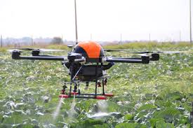
If you decide to purchase a drone, consider what you want it to accomplish before you buy. That may seem obvious, but doing your homework now will help you avoid disappointment later. There are tens of companies, drone types and price points in the agricultural market. Where to start? AgriTech Tomorrow, an online trade magazine, reports that “AeroVironment, DJI, DroneDeploy, GoPro, PrecisionHawk and Trimble Navigation are some of the key players in agricultural drones industry.”
There are two basic drone types to consider: multirotor and fixed-wing. Multirotor drones tend to have a shorter battery life but are on the lower end of the cost spectrum. Horan’s DJI Phantom, a multirotor drone, retails in a bundled package (includes a transmitter, battery and case) for about $1,500 on Amazon. He says a “starter drone” costs about half that amount.
“If you had a one-time insect infestation that the drone helped you identify and treat, that would probably more than cover your $750 investment,” he says.
Farmers wanting to cover a lot of acres, should consider buying a fixed-wing drone. It will cost you more upfront but has a longer battery life. For instance, the Quantix has enough juice to fly 45 minutes and cover up to 400 acres in a single flight.
As for analyzing the data, there is software available that farmers can purchase for that purpose, but most farmers find that time-intensive. Horan says a better option might be to subscribe to an online service. The cost is often less than $100 a month, and some providers will allow you to subscribe short-term.
“Some companies will let you try out their service on a limited basis for free,” he adds.
In Lantrip’s case, he likes flying his quadcopter manually over fields to take video and still pictures that he can then review weekly to see how his crops are progressing. He also does “programmed flights” with his drone to map entire fields and get NDVI (normalized difference vegetation index) imagery, information provided by Granular.
“I get a lot of information from the NDVI pictures that helps me find and treat diseases and pests, and I can overlay those images with my yields map to improve my ROI,” he says. “This was a real incentive to go to the effort to buy a drone and get my license. It’s all about the bottom line, and the drone helps me improve my productivity.””
https://dronelife.com/2019/03/28/drone-earns-its-keep-in-indiana-farm-with-an-roi-between-10-and-20-times-cost/


