Bridger Aerospace is on the front lines of fighting wildfires with drones. We got the inside look at their operations.
By DRONELIFE Staff Writer Jim Magill
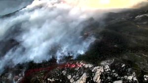
As wildfires continue to ravage vast swaths of land across the western United States unmanned aerial vehicle operators are stepping up to provide critical services, acting as eyes in the skies in support of firefighting teams on the ground.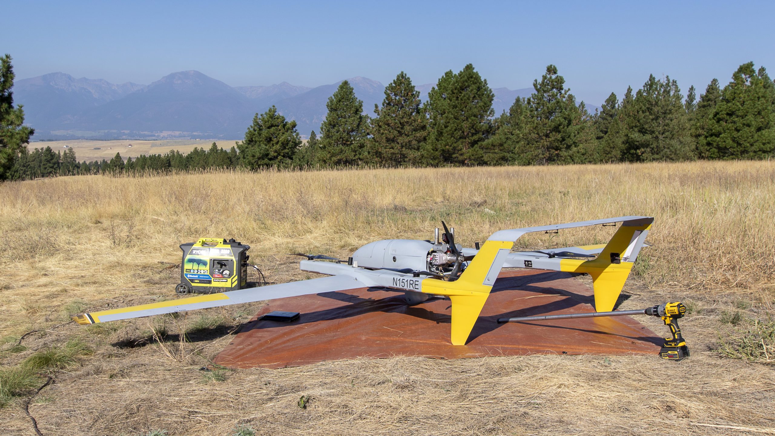
Flying two hybrid quadrotor (HQ) aircraft manufactured by L3Harris Technologies, Belgrade, Montana-based Bridger Aerospace, has flown some 250 hours in about a dozen firefighting missions across several western states, Weston Irr, Bridger’s director of unmanned aircraft systems, said in an interview.
The Right Tools for Fighting Wildfires with Drones
The fixed-wing 90-pound drones’ design and technological features equip them to be deployed to battle wildfires in remote areas. The gasoline-powered aircraft are capable of taking off vertically, like rotary-powered drones. They can remain aloft for 12 hours, although on a typical mission, they are deployed for a six- to eight-hour flight. They’re outfitted with dual-camera systems, for both day and night operations.
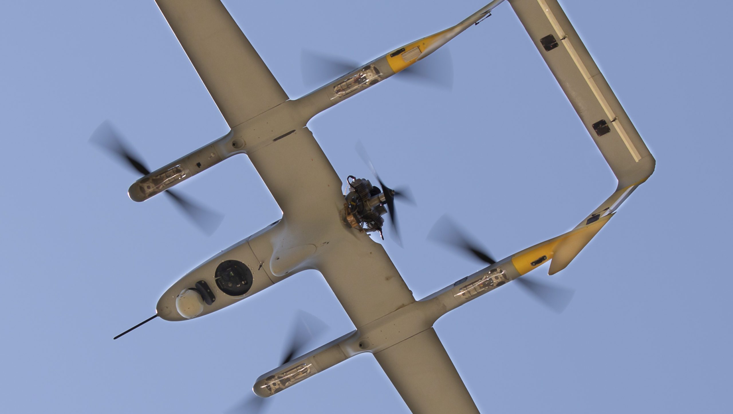 With a wing span of 14 feet, the HQ-90 aircraft can be disassembled for easy transport to a fire scene in the bed of a pickup truck and because of their vertical take-off and landing (VTOL) capability, they don’t need a runway and can take off from virtually any open area within close proximity of the fire.
“The use of runway or landing strip is not a typical luxury that everyone gets,” in wildfire situations, Irr said. “You can launch using a small meadow or a little clearing in the trees.”
Bridger has been approved under a special government interest waiver (SGI) to fly its aircraft beyond the visual line of sight (BVLOS) in wildfire situations, which has given the company the ability to deal with some of the massive wildfires sweeping the West.
For example, the Bridger team was recently deployed to battle the massive Mullen fire, east of Laramie Wyoming, which burned across more than 176,000 acres of Wyoming and Colorado. “It spanned an area about 30 miles wide and 40 miles long. Our ability to operate BVLOS allowed us to pretty much cover the entire fire from one launch location,” Irr said.
 The HQ-90 drones’ camera systems allow the aircraft to operate in low-visibility situations, such as in a smoke-filled sky or at night, when manned aircraft are unable to fly. “In smoky environments the infrared capability on our system allows us to see right through that smoke,” Irr said. “We have a really good advantage in those situations because we can see and the system is fully capable of operating.”
Bridger, which began as an aerial wildfire management operator using manned aircraft in 2015, began adding drones to its firefighting arsenal in the 2018 fire season. It utilized a Type 2 vehicle – a drone capable of flying for more than two but less than six hours — produced by Silent Falcon UAS Technologies to create maps that allowed firefighters to gauge the extent of a wildfire’s spread.
Last year, the company moved up the HQ-90 UAV, a Type 1 aircraft, a category which includes any aerial vehicle capable of flying for more than six hours. The longer flight time allowed Bridger to continue to perform its mapping function, while adding aerial surveillance and reconnaissance to its firefighting capabilities.
“Once we complete our mapping mission, we’ll go into a surveillance support role where we’ll fly over certain sections of the fire for a longer period of time to give them extra eyes, or infrared imagery where they need it the most,” Irr said.
Federal Contracts for Fighting Wildfires with Drones
Bridger performs its firefighting role under an interagency contract administered through the U.S. Interior Department, which allows state agencies and other federal agencies to contract for its services. “We’ve supported a vast number of those agencies, but the most common is either the DOI itself, using its own contract, or the Forest Service,” Irr said.
The company recently also worked on a two-day project with Cal Fire, California’s state firefighting agency under a separate agreement. The project served as a proof-of-concept trial for the state agency. “They wanted to see if a Type 1 UAS could be safely implemented into their operations,” he said.
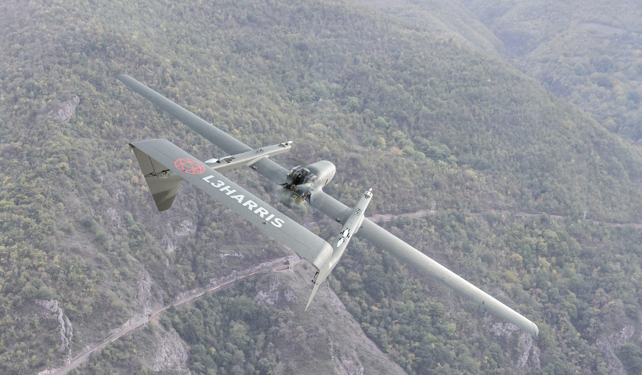
Through its contracts with Bridger and another drone company, L3Harris has seen its aircraft fly more than 1,000 hours with nearly 540 missions including the Cinnabar fire in Montana, Bighorn fire in Arizona, and El Dorado fire in California. L3 Harris, which provides technical support for its partners, produces the aircraft in compliance with DOI regulations prohibiting the use of drones manufactured in China or containing significant Chinese-made components.
The drones are engineered in Tucson, Arizona and manufactured in Ashburn, Virginia.
Peter Blocker, director of the fixed-wing vertical take-off and landing rotator program at L3Harris, said although the aircraft are capable of reaching an altitude of 20,000 feet, in firefighting situations they are usually flown at altitudes of between 6,000 feet and 8,000 feet. “That keeps them up from most of the harm of the fire, but close enough that we can keep track of the firefighters and communicate with them.”
He said the aircraft’s dual-camera configuration gives them the flexibility to adapt to multiple fire-fighting situations. “They can pick up hot spots with the IR (infrared) side of the camera or watch where the firefighters are with the day camera to show where the fire is relative to the firefighters,” he said.
The aircraft can also serve as communications relay stations, transmitting messages from the fire headquarters to firefighters on the ground below. “That way they don’t get stuck in a canyon where they can’t get communications and are able to find out in what direction the fire is coming from,” Blocker said.
In addition to taking part in active firefighting operations, the aircraft can also help provide important data before a fire starts or after one is extinguished. For example, the drones can be equipped with meteorological sensors that can measure how much humidity is in a particular area to determine the likelihood of a fire starting in that area. After a fire they can be flown over the burn area to determine which areas are likely to be vulnerable to flash floods from water runoff.
Images courtesy L3Harris
Miriam McNabb is the Editor-in-Chief of DRONELIFE and CEO of JobForDrones, a professional drone services marketplace, and a fascinated observer of the emerging drone industry and the regulatory environment for drones. Miriam has penned over 3,000 articles focused on the commercial drone space and is an international speaker and recognized figure in the industry. Miriam has a degree from the University of Chicago and over 20 years of experience in high tech sales and marketing for new technologies.
For drone industry consulting or writing, Email Miriam.
TWITTER:@spaldingbarker
Subscribe to DroneLife here.
https://dronelife.com/2020/11/02/fighting-wildfires-with-drones-on-the-front-lines-with-bridger-aerospace/


