Coutesy: Wingtra
Swiss drone manufacturer Wingtra is helping its neighbor improve road safety and save thousands of taxpayer kroners.
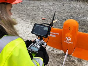
The company provides Statens Vegvesen, Norway’s Public Roads Administration with vertical-take-off-and-landing drones to survey roads for data analysis and construction projections.
Norway’s road system has been consistently ranked as the safest in Europe. Oslo wants to reach zero traffic fatalities by 2024 – a goal that requires precision road inspection and construction.
Last year, the agency started using the WingtraOne for road-construction surveys and officials immediately realized time and cost savings. The WingtraOne is a hybrid drone – a combination of fixed-wing and multi-rotor – and launches as a vertical take-off and landing aircraft.
“Another advantage of Wingtra is the VTOL. We looked at fixed-wing drones, but they need a passage to land, and we often have small places for landing. We can take off and land everywhere with WingtraOne,” NPRA chief engineer Gry C.S. Kjellsmoen said.
Kjellsmoen explained that a road survey covering around 3 square miles requires three WingtraOne flight plans, lasting between 18 and 22 minutes each. This adds up to approximately one hour of flight time.
“Traditionally, it would take me about five days in the field with a scanner to get the data we get in an hour with WingtraOne, and then I’d have to edit it inside afterward,” she said.
“We use the drone data to see how much stone and sand is moved in and out [in road construction]. We have a database with information about all the roads in Norway,” Kjellsmoen added. “We also use it to control the data and check that it’s correct.”
In 2017, Wingtra joined forces with Kentucky-based Precision Capture, a company that provides 2D and 3D data capture, measurement and imagery solutions. That same year, the company entered into a similar partnership with photogrammetry giant Pix4D.
Swiss engineering firm Cavigelli Ingeniuere AG hired Wingtra to map Lumnezia, a Swiss Alpine valley, to prepare for a major wind turbine construction project. The project calls for construction of 20 wind turbines, producing 60 GWh of power for 15,000 households.
Jason is a longstanding contributor to DroneLife with an avid interest in all things tech. He focuses on anti-drone technologies and the public safety sector; police, fire, and search and rescue.
Beginning his career as a journalist in 1996, Jason has since written and edited thousands of engaging news articles, blog posts, press releases and online content.
Email Jason
TWITTER:@JasonPReagan
Subscribe to DroneLife here.
https://dronelife.com/2019/12/31/wingtra-drones-help-norway-build-safer-roads/


