Ask any Thai rice farmer to describe government assistance when they are hit with natural disasters. Their answers will most likely be the same: Too little, too late.
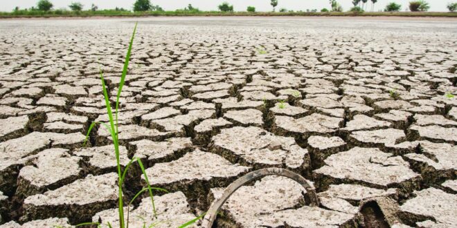
In an occupation with already high investments, farmers are at the mercy of Mother Nature, which has become increasingly erratic and wrathful. Natural disasters reduce farmers’ income, due only once or twice a year, and ramp up the production costs if they need to replant. The most vulnerable are farmers who rely on rainwater outside irrigated areas.
Without effective global warming policies, the 3.5 million rice farming households in Thailand are bearing the brunt of the climate crisis. Climate disasters are causing severe poverty and making political disenchantment inevitable.
At present, the government’s Natural Disaster Relief Programme operates two schemes to help rainy-season farmers. The first one, starting in 2002, covers the damages from all kinds of natural disasters, but the coverage is worth only 30% of the production cost. 87% of areas compensated by the programme are damaged by flood or drought.
The second one is the Thai rice insurance top-up scheme. Starting in 2011, the insurance covers national disasters and uses the farm damage data from the Relief Programme. A joint effort between the Bank for Agriculture and Agricultural Cooperatives and the Thai General Insurance Association, this scheme also covers only 30% of the farmers’ investment.
In the wake of increasing natural disasters, the Thailand Development Research Institute (TDRI) recently conducted research entitled “Re-Designing Climate Risk Management Scheme for Thailand’s Rice Production” under the Adaptation Finance Fellowship Programme (AFFP) with support from the International Development Research Centre (IDRC) from Canada and the Thailand Research Fund (TRF).
Our research shows that both compensation programmes are beset with at least four hurdles.
Firstly, the damage assessment process takes too long, making the assistance untimely, thanks to manual field inspection and lengthy bureaucratic red tape.
The damage assessment takes 95-115 days from the day the areas are declared disaster zones to the eventual completion of the registration for relief approval. While the insurance payout can be issued within 15 days thereafter, it takes several more months for the Relief Programme if the requests need to be forwarded to the central authorities for a final decision. The delay affects the farmers’ cash flow management which may force them into debt.
Secondly, the operational costs of the compensation programmes are exorbitant. The damage assessment process costed 295 million baht on average per year from 2016-2018. With global warming, this cost could rise at a rate of 0.6-3.1% per year.
Thirdly, the relief and rice insurance schemes only cover the farmers who have lost all their crops from natural disasters. Those who have partial losses get no state assistance.
Fourthly, the criteria for declaring disaster zones by the provincial governor are designed for large-scale natural disasters affecting many communities. If the affected areas are small, or beyond the administrative boundaries of the majority of the damage, they cannot be declared as disaster zones and, therefore, are not eligible for compensation. The absence of relief or insurance payouts also affect the farmers’ cash flow.
According to the Thai General Insurance Association, an estimate of at least 4.5% of farmers in the insurance scheme request for a reconsideration of their case. Despite the contract terms, payment is granted as a special favour from the insurers on a limited rolling basis. Modern technology can come to the rescue.
The use of modern satellite technology can significantly reduce the bureaucratic red tape and man-hours needed for damage assessment procedures.
The maize insurance programme is the only example of weather index insurance in Thailand, using rainfall data from weather stations to assess the damage on the ground. But this method is currently inadequate because there are too few stations per area.
The goal of this research is to identify a weather index which reflects overall damages more accurately than weather stations, and covers both partial and total damages caused by flood or drought. In this weather-index based insurance, the insurers will pay the compensation when the weather index is higher or lower than the set standards.
For floods, we have developed a model to assess the damages with a satellite radar photography technology called SAR, short for synthetic-aperture radar. From a satellite, the radar can penetrate the clouds to produce two-three dimensional images of the targeted areas.
This radar technology incorporates data from several satellites such as COSMO Skymed, RADARSAT, and Sentinel 1 to produce a comprehensive image of the target with the resolution at 1.30 metres.
For droughts, a handy piece of technology to assess the affected areas is the high-precision, high-resolution Global Satellite Mapping of Precipitation (GSMaP) of Japan Aerospace Exploration Agency (JAXA). It provides real-time rainfall observations and records of consecutive dry days with an image resolution at 1.11 kilometres.
Both satellite technologies use radar to detect water on earth. The index is developed from crop models of plant growth factors in extreme weather conditions. Crop models are important tools for assessing the impact of climate change on crop production. For example, given the wet and dry days data, the crop models can predict how much crop yield will be affected. This information is helpful to prevent crop casualties.
This index-based study of satellite data shows the areas affected by natural disasters three times larger than the existing method of damage assessment. This approach can then help the farmers who suffer a partial loss of crops as well as those with total crop damages but are excluded in the registration system to receive state relief. Subsequently, the farmers will have an incentive to join the farm insurance programme voluntarily. At present, only 39% of the affected areas are in the insurance scheme. The satellite technology takes only three to five days to assess areas affected by floods and just one day for droughts.
The investment in this satellite radar technology was about 60 million baht in its first year. The operational and maintenance costs in subsequent years cost around 43 million baht annually. This will save at least 3.2 billion baht per year in social costs, namely the operational costs of the programmes and the farmers’ cost to maintain cash flow above the poverty line. But the current satellite technology is still only 83 to 87% accurate. It tends to show larger affected areas than the reality on the ground, especially during flooding disasters, due to not having the Digital Elevation Model which shows detailed topographical data. Real-time local information can fill the gap to increase accuracy of satellite products. Crowdsourcing technology helps farmers report their situations through mobile phone applications. Drone imaging (NIR) also helps with land surveying and disaster management. Farmers facing natural disasters need prompt help.
Now that there are affordable satellite radar technologies to help speed up state assistance, the climate risk management system historically ridden with red tape and inefficiency is due for an urgent revamp.


