

Source: Skyward
Oregon-based drone company Skyward today announced a new feature for its Aviation Management Platform.
Live Flights supports program oversight and risk mitigation — users can monitor their drone flights in real time via a device app. Company officials added, the new feature will serve as a foundation of their Remote ID rollout.
“For managers in the office, this empowers greater oversight and transparency across the organization,” Skyward product manager Sam Ewen writes in a blog post. “For pilots in the field, it increases situational awareness and supports coordination during complex aviation operations.”
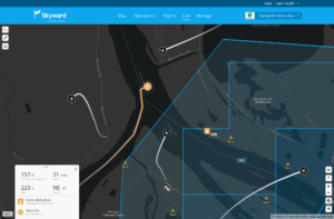
Subscribers flying with Skyward’s InFlight mobile GCS transmit aircraft information into the Live Flights map, which depict the drone’s location and flight path over the previous 60 seconds. Clicking on a drone map icon will display its ID, location, altitude and velocity as well as GCS location and key pilot information.
“Customers with an Enterprise Skyward subscription will use InFlight to self-report their location, flagging the position of items such as vehicles, observers, drones not compatible with InFlight, or landmarks,” Ewen added. “And, administrators of enterprise accounts can see live flight information for all the organizations they manage.”
Ewen added that, the feature’s ability to transmit position and identification data live will pave the way for Skyward to become a Remote ID UAS Service Supplier (USS).
“Skyward lets program managers know who’s flying and where, improving visibility and compliance for enterprise drone programs. Tomorrow, we look toward a system of Universal Traffic Management in the National Airspace System.”
In 2017, Verizon acquired Skyward, marking a milestone in drone tech’s role in multi-national corporate strategy. The global telecom joined Intel in becoming one of the first Fortune 500 company to invest in the drone sector.
In 2018, Skyward, along with other leading drone companies, was named as a partner in the FAA’s Low Altitude Authorization and Notification Capability (LAANC) initiative. The collaborative program between the FAA and drone industry stakeholders provides near real-time processing of airspace authorizations for Part 107 drone operators seeking to fly in controlled airspace.


Jason is a longstanding contributor to DroneLife with an avid interest in all things tech. He focuses on anti-drone technologies and the public safety sector; police, fire, and search and rescue.
Beginning his career as a journalist in 1996, Jason has since written and edited thousands of engaging news articles, blog posts, press releases and online content.
Email Jason
TWITTER:@JasonPReagan
Subscribe to DroneLife here.
https://dronelife.com/2020/04/13/skyward-launches-new-drone-flight-data-feature/


