By DRONELIFE staff writer Jim Magill
Following a successful two-year pilot program, international oil and gas company Shell will employ a small fleet of drones to fly over more than 500 oil and gas sites in the Permian Basin of West Texas and southeastern New Mexico, searching for leaks of methane, a potent greenhouse gas.
In a recent statement, Shell said it had reached an agreement with Avitas, a Baker Hughes-owned venture, to expand its current use of drones employed as part of its existing methane leak detection and repair (LDAR) program in the basin.
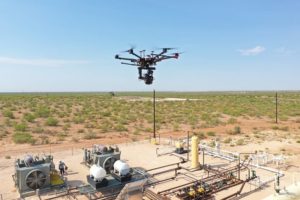
Avitas, which had deployed two drones during the pilot phase of the program, will continues to fly a pair of drones in the current deployment program, a Shell spokeswoman said. In the pilot phase of the program, the Shell-Avitas team had used two types of drones, AeroVironment VAPOR 55 all-electric helicopter and the DJI M600 Pro. However, in the operational phase of the program the team has opted to fly the M600 exclusively.
“During the pilot phase, we have conducted more than 500 test flights, during which we have assessed the capability and reliability of drones and drone-mounted sensors, perfected inspection protocols, calibrated artificial intelligence (AI) enabled software platforms and developed data collection profiles,” the spokeswoman said.
“Based on the pilot program, we know that drone-based cameras and sensors combined with Avitas’ advanced computer vision and machine-learning analytics provide a valuable source of insight.”
Drones equipped with an optical gas imaging (OGI) camera and a laser-based detection system will conduct aerial inspections over a variety of Shell sites across the basin, including well pads, central processing facilities, saltwater disposal plants and compressor stations, all of which have the potential to be sources of methane emissions.
Methane, an odorless and colorless gas, is the main component of natural gas. It’s a powerful greenhouse gas, with 28 times the heat-trapping power of carbon dioxide over a 100-year span. The Permian Basin drone program is aimed at helping Shell achieve its corporate goal of limiting its methane emissions intensity from its operated oil and gas assets below 0.2% by 2025.
Avitas CEO Jason Roe said the key to the methane detection and repair program lies in the integration of the physical asset, the drone, with the cyber component of analyzing the data collected by the drones.
“We have an advanced cyber/physical integration team that will take the drone platform and couple it with the sensor technologies,” Roe said in an interview.
“The cyber physical integration of getting the sensors on board, knowing the right flight paths, the automation of the flight paths and everything else takes quite a bit of planning,” he said.
There’s also a great deal of “art” going into ensuring a smooth interface among all the components of the system, “making sure that the right metadata goes into the right places for proper ingestions into our web-based platform,” Roe said.
“In addition, we can use computer-vision algorithms to drive additional findings on the sites, beyond just the methane detection itself,” he said.
Avitas, which has licensed drone pilots on its staff, generally sends its own team into the field along with their equipment to perform the inspections, although Roe said that on occasion the company has subcontracted the work out to others from the growing community of drone pilots in the region.
On its website, Shell envisioned an even greater expansion of its drone program in the region. The company said that in the future, the use of drones has the potential to extend the major oil company’s reach across its 500,000-acres area of interest in the Permian Basin, which encompasses 1,300 operated and non-operated oil and gas wells.
Although the company has long used surveillance drones in other regions of the world where it operates, it has faced challenges to expanding its drone operations across its vast U.S. oil and gas shale assets, because of the U.S. aviation regulations requiring drones to stay within range of the pilot’s vision, Shell said.
In September 2018, the Federal Aviation Administration granted Avitas Systems first approval to fly drones for civil use beyond the visual line of sight (BVLOS) with the assistance of radar in Loving County, Texas.
During the pilot phase, the Shell-Avitas team tested BVLOS flight for its drones. However, for the time being the team has decided not to include BVLOS flight as part of its current Permian deployment program.
https://dronelife.com/2020/09/22/methane-detection-shell-expands-drone-based-program-in-the-permian-basin/


