A Brief History of the Remo-M (Remote Mapper)

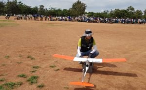
Image courtesy African Drone Forum
Safety is Supreme
In the Lake Kivu Challenge, the observers- global stakeholders all considering new technologies for big projects – had one overriding concern: safety. The Remo-M user interface software demonstrates clear geo-fencing features; a safe, programmed response to loss of C2 links; and appropriate redundancies to ensure sustained flight. Additionally, the wide wingspan design contributes to flight stability.
Precision Mapping
That flight stability – and an advanced gimbal – contributes to precision. The Remo-M won the Lake Kivu Challenge by successfully and accurately identifying not only specified positions on a remote island, but also on moving boats in the water. “The Remo-M’s wide wingspan design and gimbal allows a very reliable shot stability, ” Hojun’s Andrew Cho says.
 Designed for Unique Geographies
“The Remo-M has a steep climb in the takeoff and deep-stall landing feature which gives the ability to takeoff and land in small spaces,” explains Cho. “This provides ease and flexibility of flight mission planning, allowing to operate in all types of terrain. This was one of engineering features that the Korean Army required, because of the rough mountainous geography of Korea – they needed the versatility to conduct tactical operations in difficult environments.” Remo-M’s unique landing method also means that the drone functions without infrastructure in any environment.
Global Reach
The ability to fly anywhere is one of the reasons that Hojung Solutions has developed the Remo-M mapping drone. South Korea boasts a highly advanced remote sensing network and GIS mapping capabilities supported by one of the most developed telecommunication infrastructures in the world. Hojung has excelled in the fiercely competitive South Korean GIS mapping industry, winning industrial and government clients include the Ministry of Land, Infrastructure and Transportation, Korea Land and Geospatial Informatix Corp., and numerous local governments.
Hojung’s drone-based GIS survey solution was recognized as an effective methodology at the World Bank’s Land and Poverty Conference in 2019, and the company is committed to working on global projects in any part of the world. In mountains, valleys, deserts or jungles, the Remo-M is ready to fly.
Miriam McNabb is the Editor-in-Chief of DRONELIFE and CEO of JobForDrones, a professional drone services marketplace, and a fascinated observer of the emerging drone industry and the regulatory environment for drones. Miriam has penned over 3,000 articles focused on the commercial drone space and is an international speaker and recognized figure in the industry. Miriam has a degree from the University of Chicago and over 20 years of experience in high tech sales and marketing for new technologies.
For drone industry consulting or writing, Email Miriam.
TWITTER:@spaldingbarker
Subscribe to DroneLife here.
https://dronelife.com/2020/05/21/remo-m-mapping-drone/


