According to officials, drones with high-resolution fitting cameras will be used to map land parcels in the villages and to establish the positions of village boundaries, canals, and roads in these villages. The Centre purchased around 200 drones to map the country’s 6.62 lakh villages.
The Survey of India has provided the state with 25 drones to help speed up the land survey project. According to officials, drones with high-resolution fitting cameras will be used to map land parcels in the villages and to establish the positions of village boundaries, canals, and roads in these villages.
The Centre purchased around 200 drones to map the country’s 6.62 lakh villages. Of these, 25 drones were given to the state. The government aims to complete the survey mapping of these villages by the end of 2024.
“With a target of mapping 39,723 villages in the state, only 2,000 villages have been covered so far owing to the pandemic,” officials stated.
By mapping land parcels using drone technology, the scheme was launched to create accurate land records for rural planning and reduce property-related disputes.
“Mapping was earlier carried out manually, but the drone technology is now changing the way this massive exercise is undertaken. Once extended to other areas and completed, the process is also expected to boost government’s revenue collection,” he added.
The program, which launched in Sonori village in Pune district’s Purandar tehsil in 2018, has so far covered 2,000 villages.
“This procedure can complete mapping of a town in 2-3 days, which otherwise would have taken months,” the revenue official said.
Drones can truly aid and benefit farmers in the following ways:
The uses and benefits are plentiful if farmers embrace drones and technology. Here is a shortlist:
-
Crop monitoring – Under this, farmers have the option to continuously monitor their crops and conduct surveillance at their convenience.
-
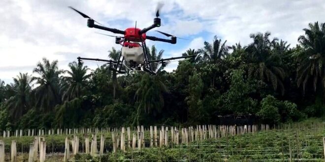
Crop protection – By using drones, crops can be protected too. Spraying chemical pesticides at the right time in the right quantities can improve the quantity of products as there is minimal wastage and maximum output.
-
Increase in productivity – Farmers using drones can also increase their productivity per acre as they use less labor for spraying pesticides or fertilizers to cite one example. Even manual surveillance can be eliminated using drones to surveil and protect.
-
Crop plantation – The manual work of planting trees and crops earlier done by farmers can now be replaced with drones as it will help save on labor, costs, and fuel too. As organic and sustainable farming is being embraced by many not only in India but globally, drones can eliminate the need for tractors thus helping the environment too.
Show your support to Agri-Journalism
Dear patron, thank you for being our reader. Readers like you are an inspiration for us to move Agri Journalism forward. We need your support to keep delivering quality Agri Journalism and reach the farmers and people in every corner of rural India.
Every contribution is valuable for our future.
Contribute now


