Drone mission-software provider UgCS (or SPH Engineering) is partnering with Airborne Response to enhance UAV-led search and rescue efforts.
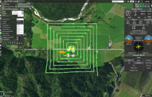
UgCS software enhancements includes customizable search patterns such as the “expanding square” and “creeping line” that can be used in both search operations and on other missions.
“Based on the flight altitude input by the operator, the UgCS software will automatically calculate key variables such as the course heading and track spacing necessary to provide the prescribed coverage area for a search target,” a company statement explains.
“As first responders, we are trained to develop an emergency search plan using time-tested and proven tactics,” says Tom Oatmeyer, Chief Pilot, Airborne Response. “The new enhancements to the UgCS mission planning software will allow remote pilots at every skill level to quickly plan and implement a professional search mission with a UAS.”
“The new UgCS search feature is designed to make searching for a target with a drone as simple and reliable as possible,” said Janis Kuze, Sales Director of SPH Engineering.
Additionally, Airborne Response and UgCS have reached an agreement for Airborne Response to offer the UgCS mission planning software, and associated training, to public safety and emergency response professionals throughout the U.S.
In July, the FlU Academy for International Disaster Preparedness partnered with local first responders and Airborne Response to conduct UAS exercises in coordination with marine, land and other aviation assets.
Search and rescue drones may be the sub-sector responsible for the most saved lives across the industry.
Last year, police in North Carolina located and rescued an 81-year-old woman lost in a rural area. Within 25 minutes, a drone found her uninjured.
In 2016, a police drone successfully located a lost hunter in a swampy Minnesota wildlife area. The unidentified hunter called police to report he had lost his bearings and was stuck in waist-high water in terrain described as rugged and swampy. The $20,000 drone easily located the hunter and his dog in the forest. The pilot helped on-ground officers triangulate the hunter’s location and directed a rescue helicopter to airlift them.
Jason is a longstanding contributor to DroneLife with an avid interest in all things tech. He focuses on anti-drone technologies and the public safety sector; police, fire, and search and rescue.
Beginning his career as a journalist in 1996, Jason has since written and edited thousands of engaging news articles, blog posts, press releases and online content. He has won several media awards over the years and has since expanded his expertise into the organizational and educational communications sphere.
In addition to his proficiency in the field of editing and writing, Jason has also taught communications at the university level and continues to lead seminars and training sessions in the areas of media relations, editing/writing and social media engagement.
Email Jason
TWITTER:@JasonPReagan
https://dronelife.com/2018/08/18/drone-software-firm-teams-up-with-experts-to-make-searches-easier/


