


Continue reading below, or listen:
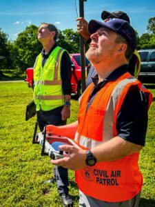
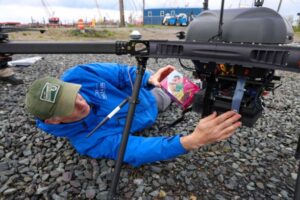
The North Carolina Wing has been at the forefront of the Civil Air Patrol small Unmanned Aerial Systems (sUAS) program that culminated in the first locate and save within CAP in August of 2021. On May 6th, the program introduced an increase in training and equipment at the NCWG headquarters. The NCWG partnered with the North Carolina Division of Emergency Management to obtain ten Teal 2 drones, which were purchased by Emergency Management and given to the NCWG Civil Air Patrol to offer statewide drone support upon request.
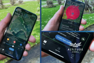

UTM (Unified Traffic Management) technology leader Altitude Angel has announced that it will be releasing an updated version of its Drone Assist flight planning tool. The update will bring a suite of new features, including enhanced integrated flight planning, advanced flight plan drawing tools, and approval services via the app.
Who’s Leading the Counter UAS Race? The Drone Radio Show Podcast
Counter UAS on the Drone Radio Show Podcast! Mary Beth Long, Board Member at Red Cat Holdings, talks about the current challenges and opportunities for counter drone solutions and the future of protecting critical assets from drone incursions.
Airsentinel Launches Drone Detection App that Works (and Respects Drone Operators)
Drone detection can be a touchy subject in the commercial drone industry. Rem0te ID for drones gives stakeholders the capability to identify unmanned aircraft and their pilots, helping reduce the risk of unauthorized drone incursions – thereby supporting the expansion of the legitimate commercial industry. Some operators, however, are legitimately concerned that having pilot location and identification data made public could lead to unintended negative consequences. Drone manufacturing leader DJI developed a solution that made drone detection as easy as possible for pilots in 2019, but was criticized when demonstrating their first drone detection app amid fears that the app provided too much information to too many people.
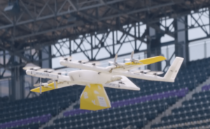

Earlier this month, Google’s Wing held a demonstration delivery at Colorado’s Coors Field, where it delivered beer and peanuts to the field. Though not held on a game day, over 1,000 people were present in the stands to celebrate the kickoff party for AUVSI’s annual autonomous systems conference. Coors Field was selected for the demonstration due to its challenging environment. Located in Denver, Colorado, one of the country’s fastest growing cities, the stadium is filled with obstacles for delivery such as stadium seating and jumbotrons. At 5,200 feet, Coors Field sits a “mile high” in North America’s second tallest city.

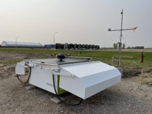
Today, weather intelligence and technology company Meteomatics launched its first U.S. Meteodrone autonomous flight system at North Dakota’s GrandSKY aviation park. Meteodrone is capable of reaching altitudes of up to 20,000 feet to fill the meteorological data gap in the lower and mid atmosphere–regions, crucial for predictability and reliability in aviation and business forecasting. Meteomatics is collaborating with GrandSKY and low altitude weather technology specialist TruWeather Solutions to develop the U.S.’s first state-wide micro weather service in North Dakota. Meteomatics’ high-resolution forecast model accounts for all weather details, data points and parameters in a given square kilometer, and will power TruWeather’s decision analytics to enable real-time weather forecasts nine times more granular than the best available government services.


Leading VTOL drone producer Wingtrahas revealed its new RGB61 sensor payload. Compatible with the WingtraOne GEN II drone, the RGB61 paves the way forward for the entire drone mapping industry. The Sony Alpha 7 Mark IV 61MP RGB camera has been customized to provide the most efficient, data-light UAV data solution available, with in-app light-settings control and ultra-high accuracy image capture.


The new Gremsy 2-Axis Mio gimbal is a front-mounting gimbal engineered for industrial applications. Gremsy is a global leader in drone gimbals, specially engineered to give drone operators the stability and features they need for better data and professional level results. The new Gremsy two-axis Mio is designed for industrial applications, optimized for weight and size and built for small drone platforms. The 2-axis Mio weighs less than 30% of the original Mio, and is a top choice for drone developers and integrators who want to minimize payload.


Drone solutions provider Everdrone and Air Ambulance Charity Kent Surrey Sussex (KSS) have announced a collaboration to begin implementing Everdrone First on Scene Grid™ technology in the UK. The goal of the collaboration is to allow KSS to broaden the scope of its rapid response service with the addition of drone delivery of time-sensitive essential medical supplies, advancing pre-hospital emergency healthcare across Kent, Surrey and Sussex.
A year after launching a new Girl Scout badge to encourage and educate girls in STEM careers, the Port Authority of New York and New Jersey commemorated the partnership with the delivery of a box of Raspberry Rally cookies across the Hudson River, which served as the payload for the agency’s first test of a small unmanned delivery aircraft. The box of cookies traveled 3 miles from Greenville Yards in Jersey City, N.J., to the New York New Jersey Rail’s (NYNJR) eastern terminus in Brooklyn, N.Y. in only 15 minutes, and the drone made the return trip in 10 minutes.


Miriam McNabb is the Editor-in-Chief of DRONELIFE and CEO of JobForDrones, a professional drone services marketplace, and a fascinated observer of the emerging drone industry and the regulatory environment for drones. Miriam has penned over 3,000 articles focused on the commercial drone space and is an international speaker and recognized figure in the industry. Miriam has a degree from the University of Chicago and over 20 years of experience in high tech sales and marketing for new technologies.
For drone industry consulting or writing, Email Miriam.
TWITTER:@spaldingbarker
Subscribe to DroneLife here.
https://dronelife.com/2023/05/26/drone-news-of-the-week-may-26-dronelife-headlines-and-story-excerpts-all-in-one-place-to-read-or-listen/


