

Drone-management firm Kittyhawk is hoping to live up to its aviation pioneering namesake with the launch of a new UAV air-traffic app.
Partnering with Airmap, an airspace information service provider, San Francisco-based Kittyhawk has developed an iOS app that will allow users to receive live air-traffic alerts without exiting the app.
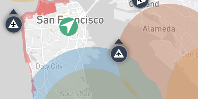
Built on the Airmap platform, Kittyhawk’s new app – which bears the company’s name when searched in the Apple App Store – allows drone users to send a “digital notice” with data about their planned flight path to more than 150 airports and other UAV pilots.
“Kittyhawk had previously stayed away from providing in-flight intelligence, but the AirMap platform presented the right opportunity for us to work with another industry leader on creating an exceptionally useful feature,” Kittyhawk Chief Pilot Joshua Ziering said in a press release.
Other features of Kittyhawk include:
- Live sharing of drone flights
- FAA 333, Part 107, and drone hobbyist compliance features
- Preflight module with hyper local weather and Kp index
- Flight timers and stopwatch features
“The iOS app is the newest tool in our suite of technologies that allows people to communicate with our airspace management system,” AirMap co-founder Greg McNeal said.
“The AirMap ecosystem includes software integrations into DJI, 3DR, and Yuneec. It includes over 80 airports in the United States, including major hubs like Los Angeles International, Houston Intercontinental, and Denver International, as well as Air Force bases.”
Airmap is fast becoming a popular platform for drone-management solutions. In May, the company released its own iOS app fueled by its proprietary Digital Notice and Awareness System (D-NAS).
The system allows drone users to transmit data to airports with real-time, digital geo-location information. Air-traffic professionals can then access the location data via the AirMap D-NAS dashboard, providing a map view of nearby drone flights.
In July, Airmap teamed up with target=”_blank”> target=”_blank”> target=”_blank”> target=”_blank”> target=”_blank”> target=”_blank”> target=”_blank”>DJI to enhance its current geofencing data database to include areas experiencing wildfires. The system gathers wildfire-location data directly from the Department of Interior and transmits it to drone pilots via its flight-control apps and AirMap’s geofencing system native to DJI’s GO flight control app.


