10:49 am
Black Swift Technologies, Commercial Drones, Drone, drone integration, Drone News Feeds, GPS-denied navigation, News, NOAA
NOAA has awarded Black Swift Technologies (BST) a contract to develop GPS-denied navigation, enabling Beyond Visual Line of Sight (BVLOS) operations for drones in GNSS-denied environments. NOAA has almost 95,000 miles of domestic coastline to survey – and while drones are by far the best way to complete the mission, flying …
Read More »
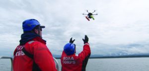
2:26 pm
aquatic drones, autonomous drones, Conservation, Drone, Drone News, Drone News Feeds, News, NOAA
Source: NOAA It’s not an Ark, but NOAA is charting a new course for aquatic research using autonomous drones. The federal agency recently launched a sea-going sortie of three aquatic drones bound for the Bering Sea. The drone fleet will survey the nation’s largest fish stock and monitor changing weather …
Read More »
9:57 pm
Conservation, Drone, Drone News, Drone News Feeds, News, NOAA
Source: NOAA NOAA is predicting clear skies for a new drone program the agency rolls out this week. In a media statement, the agency announced the launch of the Unmanned Systems Operations Program. “The new program will promote the safe, efficient and economical operation of unmanned systems NOAA uses to …
Read More »
6:01 pm
Drone, Drone News, Drone News Feeds, hurricanes, News, NOAA, Safety and Security
Courtesy: NOAA Drones may someday become the first line of defense in hurricane forecasting. A NOAA research paper in Bulletin of the American Meteorological Society reveals that disposable UAS could be used to gather data from a hurricane’s lower eyewall – the most dangerous part. “It’s where the storm draws …
Read More »
10:47 am
Amazing Footage, DJI, Drone, Drone News Feeds, entangled, Enthusiasts, Featured, Hawaii, News, NOAA, oceans unmanned, Technology, Video, Whales
We’ve written on a number of events about how drone expertise is getting used for marine analysis and conservation, significantly with efforts involving our oceans’ largest inhabitants: whales. You can examine Ocean Alliance’s work to seize whale information utilizing SnotBot, right here. You can examine Intel and Ocean Alliance utilizing …
Read More »
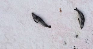
4:31 am
aerial photography, antarctica, Applications, Conservation, Drone, Drone News Feeds, Enthusiasts, News, NOAA, seals
It’s at all times good to see a optimistic drone story. Today we’ve heard a couple of new approach in which drones are serving to with conservation efforts. A mission in some of the distant components of the world, Antarctica, has proven that aerial images can be utilized to successfully …
Read More »
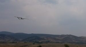
8:17 am
Black Swift Technologies, Drone, Drone News, Drone News Feeds, Firefighter, firefighting drones, Fixed wing, News, NOAA, Wildfires
The National Oceanic and Atmospheric Administration is taking swift steps to foretell wildfires by partnering with a drone agency. Colorado-based Black Swift Technologies lately introduced the drone deal – the deployment of “a tightly integrated system consisting of an airframe, avionics, and multiple sensors capable of research-quality measurements of CO2, …
Read More »
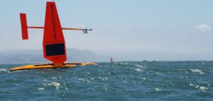
11:05 am
Business and Finance, commercial drone business, Commercial drone industry, Drone, News, NOAA, ocean drones, venture capital funding
While most people think of drones in the air, CA-based Saildrone Inc., is using drone technology on the ocean. Saildrone doesn’t call themselves a drone company, but rather “a provider of ocean data collected by a fleet of unmanned, autonomous sailing drones.” Used by NOAA as part of their drone exploration program, …
Read More »