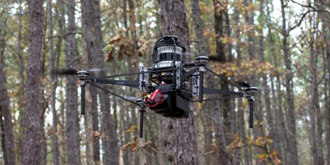
A drone collecting data in the forest using Treeswift technology.
Treeswift
One of the major challenges of managing forest lands against threats like fire and deforestation is the daunting logistical hurdle of collecting data. Drones darting through forests under the canopy may help.
The precarious-sounding premise has won a big vote of confidence from investors to the tune of $6.4 million, including a recently closed $4.8 million round. Treeswift, a startup that’s developed a drone=based solution to navigate under the forest canopy to collect vast quantities of data, including information on individual trees, announced the seed round led by Pathbreaker Ventures.
The problem is profound and it’s not hard to spot the market need.
“Our mission is to build the data ecosystem for the natural world, and we are accomplishing that by capturing important data from below the forest canopy,” said Steven Chen, Treeswift’s CEO. “We anticipate that Treeswift technology will help to obtain a more transparent, verifiable, and accurate view of the planet from the ground up.”
Not surprisingly, Treeswift is iterating on a process that’s previously been performed with a mishmash of technologies and boots on the ground measurement. Previous approaches used remote sensing methods such as satellites or planes, but this top-down method is insufficient for detailed insights about what’s going on beneath the canopy. That job has been traditionally been accomplished by human workers called timber cruisers, who take to the forest floor with journals and tape measures. Drones that employ a variety of cameras, sensors, and advanced machine learning algorithms can simply cover more ground faster while doing a more comprehensive job of collecting data sets.
That’s important for a variety of industries and use cases. Forestry data can help provide a detailed picture of fire risk, for example, by identifying highly combustible dead and damaged trees. Climate models depend on accurate measures of carbon capture, which is directly related to the health and size of trees in forests.
Treeswift is advised by Dr. Harold Burkhart of Virginia Tech’s Department of Forest Resources and Environmental Conservation and Dr. Vijay Kumar, the Nemirovsky Family Dean of Engineering at the University of Pennsylvania’s GRASP Laboratory.
Of course, tools that can be used for conservation can also be used by extractive industries, and indeed one of the primary customers for Treeswift is likely to be the commercial logging sector.
“The Molpus team has been particularly impressed with Treeswift’s ability to accurately allocate trees into product classes and to identify stem quality issues impacting value,” said Randy Taylor, Senior Director, Resource Planning of Molpus Woodlands Group. “Understanding and accurately maintaining timber inventories play an important part in managing our clients’ forests to their potential.”
The hope is that equipping the commercial forestry sector with tools to better identify and target which trees it cuts may help avoid the indiscriminate cutting methods that are destructive to habitats and soil health and can actually increase fire risk.


