 At South Korea’s major GIS and mapping show, Smart Geo Expo: new software, new drone options.
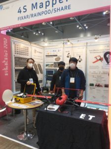
Drones and mapping applications are truly global, and DRONELIFE has been visiting shows on 3 continents this fall to find new solutions from every corner of the world. On the floor of Smart GEO Expo this week, DRONELIFE met with Korean software and services company 4S Mapper.
Drone-based surveying is a faster, safer, and better method than traditional survey methods in many cases. For surveys of road and highway infrastructure, drone-based mapping provides significant insights for urban planning, maintenance, and more. In populous urban areas like Seoul, however, the roads are used 24 hours a day, 365 days a year: it is almost impossible to get an image of a road without a vehicle.
 4S Mapper has many applications. One on display at SmartGeo is CfSM, or car-free surface mapping. With 4S Mapper, CEO Stephano Lee explains, users can take raw images of a roadway: the software uses AI-powered algorithms to remove any unwanted elements: cars, motorcycles, or manholes. This allows users to get a better overall view of the condition of the roadway, making the map more useful as a tool for inspection or repair orders.
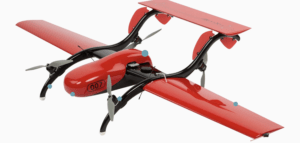 4S Mapper is drone and sensor agnostic: but displayed in the booth was a cost-effective fixed wing mapping drone. Produced in Latvia, the Fixar 007 fixed wing drone offers a flight endurance of up to 60 minutes depending on the payload. Plug in payload options and a short set up time (Fixar says less than two minutes) make it a good all around commercial option for mapping, photography, or surveillance applications.
Read more about the Korean drone industry:
CEO DroneLife.com, DroneRacingLife.com, and CMO of Jobfordrones.com. Principle at Spalding Barker Strategies. Has enjoyed working with and around the commercial drone industry for the last 10 years. Attendance and speaker at Industry Events such as Commercial UAV, InterGeo, Interdrone and others. Proud father of two. Enjoys karate, Sherlock Holmes, and interesting things. Subscribe to all things drone at DroneLife here. Email is [email protected]. Make Sure that you WhiteList us in your email to make sure you get our Newsletter. [email protected].
https://dronelife.com/2022/11/03/4s-mapper-civil-engineering-and-geospatial-software-creates-a-clean-view/


