

Canada’s SimActive and Dawson Geophysical demonstrate the use of drones with mapping and modeling software for oil and gas seismic exploration.
Knowing where to drill is a million dollar question for the oil and gas industry. Seismic exploration is one way that the energy industry can determine where commercially viable energy stores are to be found.
From Oil and Gas Lawyers:
A seismic survey is conducted by creating a shock wave – a seismic wave – on the surface of the ground along a predetermined line, using an energy source. The seismic wave travels into the earth, is reflected by subsurface formations, and returns to the surface where it is recorded by receivers called geophones – similar to microphones. The seismic waves are created either by smalle xplosive charges set off in shallow holes (“shot holes“) or by large vehicles equipped with heave plates (“Veibroseis” trucks) that vibrate on the ground. By analyzing the time it takes for the seismic waves to reflect off of subsurface formations and return to the surface, a geophysicist can map subsurface formations and anomalies and predict where oil or gas may be trapped in sufficient quantities for exploration activities.
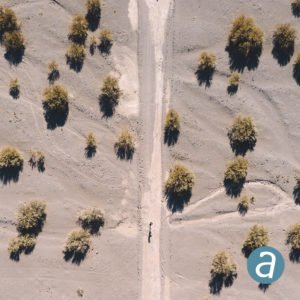
Texas-based company Dawson Geophysical is using orthomosaics and elevation models generated from aerial imagery, using SimActive’s Correlator3D, to aid in planning of seismic surveys: one more way that drones are proving invaluable tools in the oil and gas industry.
“Dawson uses a medium format camera from Phase One to fly over areas of between 20 and 200+ square miles. The collected images are then processed by SimActive software to derive highly accurate geospatial data and identify points of interest. Finally, mappers use the imagery to spot hazards and plan routes in advance,” says a SimActive release.
“SimActive’s software allows our company to survey hundreds of square miles at a much faster pace”, said Christopher Lindsey, Technical Services Manager at Dawson Geophysical. “This enables us to be more accurate, time-efficient out in the field, and to produce map products that our whole company can use.”


Miriam McNabb is the Editor-in-Chief of DRONELIFE and CEO of JobForDrones, a professional drone services marketplace, and a fascinated observer of the emerging drone industry and the regulatory environment for drones. Miriam has penned over 3,000 articles focused on the commercial drone space and is an international speaker and recognized figure in the industry. Miriam has a degree from the University of Chicago and over 20 years of experience in high tech sales and marketing for new technologies.
For drone industry consulting or writing, Email Miriam.
TWITTER:@spaldingbarker
Subscribe to DroneLife here.
https://dronelife.com/2020/07/07/the-right-tools-for-oil-and-gas-exploration-simactive-and-dawson-geophysical/


