

A key harbor in the African nation of Djibouti is safer from flooding threats thanks to Japanese drone provider Terra Drone Corporation.
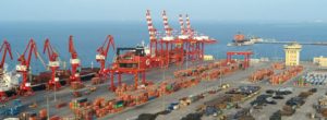
The company’s European division recently completed a five-day aerial survey of the Doraleh, one of Djibouti’s busiest ports. The high-resolution photogrammetric pavement assessment covered the city’s quay walls and sea defense revetments.
Terra Drone launched a multi-rotor UAV at an altitude of 246 feet – a mission the company said was a challenge because the height of container cranes at the site was even more than the height at which the drone’s flight path – depending on the position of the boom, the cranes could soar up to 280 feet.
The flight data will allow Djibouti officials to identify the high and low spots of the harbor pavements. Topographic data will guide the creation of a new drainage plans for port owners. The aerial photogrammetric pavement assessment will also be used to inspect the overall condition of the port.
A Terra Drone spokesperson noted:
“Traditionally, this kind of survey would have been conducted using a leveling device. That technique would have taken a lot of time and yielded only 1 point per 5 meters. The drone survey, on the other hand, produced over 20,000 height measurements per square meter.”
The contract is yet another feather in Terra Drone’s corporate cap:


Jason is a longstanding contributor to DroneLife with an avid interest in all things tech. He focuses on anti-drone technologies and the public safety sector; police, fire, and search and rescue.
Beginning his career as a journalist in 1996, Jason has since written and edited thousands of engaging news articles, blog posts, press releases and online content.
Email Jason
TWITTER:@JasonPReagan
Subscribe to DroneLife here.
https://dronelife.com/2019/06/25/terra-drone-aids-port-flooding-survey-in-djibouti/


