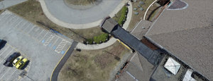
Recently, the drones have helped the St. Charles County Ambulance District save the lives of four teens trapped on a bluff on the Katy Trail. ST. CHARLES COUNTY, Mo. — A “first of its kind” rescue training is taking new heights in St. Charles County. The training is all about …
Read More »SPOTLIGHT: Point Cloud Creation and Processing in Global Map…
Pixels to Points is a photogrammetric processing tool within Global Mapper Pro that creates photo-textured 3D models, orthoimages, and high-resolution point clouds via Structure from Motion (SFM) and Multi-View Stereovision. Pixels to Points is a photogrammetric processing tool within Global Mapper Pro that creates photo-textured 3D models, orthoimages, and high-resolution …
Read More »Drones to map property, assets of all villages in Rajasthan …
During the survey, which will be conducted over the next two years (2021-22 & 2022-23), ownership records of a…Read More JAIPUR: For the first time, drones will be used to conduct a survey of populated areas in all the 46,543 villages of Rajasthan with the objective of preparing ‘village maps’ …
Read More »Drone academy students help map out Africa’s future

LILONGWE – For Ethiopian aeronautical engineer Lydia Elias, building and piloting a drone to support humanitarian and development projects on the continent of her birth has been a lifelong dream. Now, as a student at Africa’s first drone academy, she is about to make it come true. The institute is …
Read More »Underwater drones map the ocean floor
James Hunter, a marine archaeologist with the maritime museum, said “the ocean was probably the last unexplored territory on this planet”. “There are areas of our own oceans that we know nothing about,” Dr Hunter said. “We know more about the moon that we do about our own oceans.” Dr …
Read More »Singapore map tech company, GPS Lands, wants to navigate its…
SINGAPORE: Local map tech provider GPS Lands occupies an office space in a quiet, unassuming industrial nook at Jalan Pemimpin. Yet its humble home conceals its burgeoning ambitions. It is looking to offer makers of autonomous vehicles high definition maps which are more accurate than those from the industry bigwigs, according to …
Read More »World’s biggest drone rules map – Norway Today
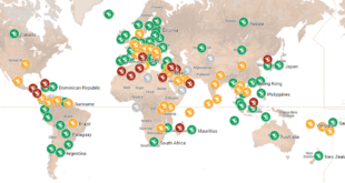
World’s biggest online drone rules map Its been about 15 years that drones are now available widely to the public for commercial purposes. With the rise of this new unregulated technology able to fly above our heads, it didn’t take long for the first incident reports to fly in as …
Read More »