

by DRONELIFE Staff Writer Ian M. Crosby
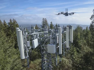
Skydio has announced its upcoming 3D Tower Capture, the newest autonomous capture mode for its Skydio 3D Scan software. 3D Tower Capture is optimized for vertical structures, starting with telecommunications towers.
Skydio 3D Scan utilizes advanced AI to autonomously fly a Skydio drone in and around a structure to capture a complete photoset of every surface necessary to generate highly detailed digital twins, quicker and with greater precision than even the most experienced pilot.
The new 3D Tower Capture mode provides numerous optimizations designed to improve the speed and efficiency of scanning of vertically shaped structures – beginning with telco towers.
The original 3D Capture mode gives users the ability to efficiently scan complex structures by setting a floor, a ceiling and at least three pillars to define a scan volume. Rather than flying the drone to set multiple pillars, 3D Tower Capture allows the user to define the scan volume as a cylinder through four simple parameters, setting a floor, a ceiling, a center and a radius. This streamlined process saves battery life and makes the scan setup much simpler and faster.
The simpler shape of tower structures also enables a simpler capture flight plan. 3D Tower Capture optimizes by defaulting its flight path to start at the top or bottom of the tower and fly a spiral path around the Z axis, reducing the number of images that are captured and in turn significantly reducing the total time spent scanning. Starting the scan from the top of the tower also improves the efficiency of larger multi-battery scans, as the drone has a shorter distance to fly when repositioning itself following the battery swap.
3D Tower Capture also defaults the camera gimbal angle to face downward, guaranteeing that images only contain important textured surfaces. Enabling the X and/or Y scan passes causes Skydio to intelligently capture horizontal elements, like the underside of antennas, without capturing excessive or redundant imagery. The sharp look-down angle of 3D Tower Capture will also increase ground capture, helping anchor the model to global coordinates, particularly when using ground control points.
Users are able to export all 3D Scan photos with full metadata to any third-party photogrammetry software to create 3D models. Skydio actively partners with companies such as Bentley, DroneDeploy, Pix4D and RealityCapture to optimize output for their platforms.
Read more about Skydio:


Miriam McNabb is the Editor-in-Chief of DRONELIFE and CEO of JobForDrones, a professional drone services marketplace, and a fascinated observer of the emerging drone industry and the regulatory environment for drones. Miriam has penned over 3,000 articles focused on the commercial drone space and is an international speaker and recognized figure in the industry. Miriam has a degree from the University of Chicago and over 20 years of experience in high tech sales and marketing for new technologies.
For drone industry consulting or writing, Email Miriam.
TWITTER:@spaldingbarker
Subscribe to DroneLife here.
https://dronelife.com/2022/02/24/skydio-3d-tower-capture-optimized-for-vertical-structures/


