

SimActive has just announced some additional functionality removes some of the manual processes currently needed to process softificated imagery. From their press release below: “Removing the need to manually tag GCPs facilitates the integration of LiDAR data with imagery”, said Dr Philippe Simard, President of SimActive. “Our clients can benefit from different data sources, with perfect co-registration.”
For some additional background, here is a recent interview that we did with Dr Philippe Simard of SimActive.
Press Release is included below:
SimActive Introduces New LiDAR Workflow
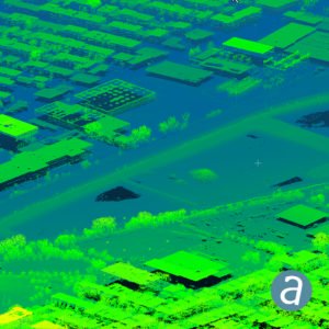
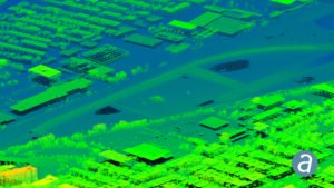
SimActive Inc., a world-leading developer of photogrammetry software, announces a new LiDAR workflow integrated in its Correlator3D™ product. The capability allows to import a point cloud in the software and to perform registration with an image dataset. Using LiDAR as control eliminates the need for traditional ground control points (GCPs) when processing the photos.
The registration occurs during aerial triangulation, leading to a precise alignment of imagery with the LiDAR data. Following this, Correlator3D™ can output colorized point clouds as well as seamless orthomosaics.
“Removing the need to manually tag GCPs facilitates the integration of LiDAR data with imagery”, said Dr Philippe Simard, President of SimActive. “Our clients can benefit from different data sources, with perfect co-registration.”
About SimActive


CEO DroneLife.com, DroneRacingLife.com, and CMO of Jobfordrones.com. Principle at Spalding Barker Strategies. Proud father of two. Enjoys karate, Sherlock Holmes, and interesting things. Subscribe to all things drone at DroneLife here.
https://dronelife.com/2019/12/05/simactive-adds-new-lidar-workflow-functionality/


