

Source: WingtraOne
Orthophoto survey drones are providing new insights to scientists tracking ice and water levels in Alaska.
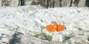
A research team led by Gabriel Wolken of the University of Alaska Fairbank’s Climate Adaptation Science Center has been measuring rising and falling ice and water levels in Suicide Basin glacial lake just outside Juneau.
By working to visualize and predict the glacial lake’s seasonal flux, the team hopes to learn how the water interacts with the Mendenhall Glacier, which sits next to the basin and holds it together.
“Mendenhall was once connected to Suicide Glacier before rising temperatures separated them, resulting in Suicide Basin,” a spokesperson said. “When basin waters rise to a point, Mendenhall Glacier can’t hold them anymore and the entire basin drains, immediately causing flash floods.”
Thanks to climate change, flash flooding across Suicide Basin began in 2011, damaging local infrastructure in the valley several times.
“This flooding potentially threatens a bridge that is connected to the road system,” Wolken said. “And this is the only road that would connect residents on the north side to hospitals and other vital facilities, so if this bridge was impacted it would cause some very serious issues for a lot of people.”

“The main issue is that it’s ice covered so we can’t really see the water as it fills up the basin on a seasonal basis,” he added.
The solution: The team relies on orthophoto survey drones by Swiss UAV manufacturer Wingtra to gather digital elevation models and imagery. The data help researchers assess changes to ice levels atop Suicide Basin.
Wolken explains:
“Alaska is a big place. There’s virtually nothing we address that we consider small here. So if it’s going to be a drone, we have to have something that can actually fly for a long time, fly high enough to be able to handle the complex terrain that we’re constantly dealing with and provide the resolution that’s required for the analyses that we’re doing.”
A VTOL orthophoto survey drone model, the WingtraOne, covers a large area efficiently, providing high-quality data in terms of visualization and location accuracy without risking the safety of a manned flight crew.
Last year, Wingtra partnered with Statens Vegvesen, Norway’s Public Roads Administration, with vertical-take-off-and-landing drones to survey roads for data analysis and construction projections.


Jason is a longstanding contributor to DroneLife with an avid interest in all things tech. He focuses on anti-drone technologies and the public safety sector; police, fire, and search and rescue.
Beginning his career as a journalist in 1996, Jason has since written and edited thousands of engaging news articles, blog posts, press releases and online content.
Email Jason
TWITTER:@JasonPReagan
Subscribe to DroneLife here.
https://dronelife.com/2020/05/15/orthophoto-survey-drones-help-predict-flash-flooding/


