

The Israeli drone delivery pilot program has now demonstrated civil drone flights in GPS-denied environments, utilizing camera-based visual navigation. “The successful test will pave the way for autonomous drone delivery in Israel,” says a press release.
The technology for autonomous drone flight is available: as is the technology for safe flight beyond visual line of sight (BVLOS.) But in order to put all of the pieces together, stakeholders need to address every possibility, and a disruption in GPS signal is one of them. “This kind of disruption can originate from a bevy of sources, including enemies seeking to disrupt a military mission, individuals using them for their own purposes, satellite malfunction, and even solar flares,” says the release.
The possibility of an interruption makes it critical for the drone industry to demonstrate other methods of navigation. “A first worldwide test of civil drone flights in GPS denied environments was successfully conducted in Israel in a special drone test zone in Yeruham, where safe navigation solutions for drone flight Beyond Visual Line Of Sight (BVLOS) were presented,” says the announcement.
“The test is part of NAAMA, the Israeli drone delivery pilot program operated by Israel’s Ministry of Transport (MOT), Ayalon Highways, the Civil Aviation Authority of Israel (CAAI) and Israel Innovation Authority, for testing and demonstrating drone technologies in managed airspace (UTM).”
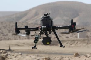
Sightec‘s NavSight system for autonomous flights based on computer vision and artificial intelligence technologies demonstrated their technologies integrated with Simplex Interactive‘s FlightOps.io drone operating system, which allows operation of multiple drones beyond visual line of sight and in shared airspace.
The NavSight system developed by Sightec enables camera-based visual situation awareness for autonomous aerial day and night missions, including vision-based navigation and landing (GPS-free), detection and classification of ground and aerial objects as well as 3D mapping & change detection for a full understanding of the ever-changing environment of the drone. NavSight turns off-the-shelf cameras into smart affordable sensors that enable the drone to “see and understand its surroundings” like the human pilot.
The “FlightOps drone operating system is the only technology certified by the civil aviation authority in Israel to fly commercial urban drone deliveries Beyond Visual Line of Sight (BVLOS) and has already performed hundreds of commercial flights as part of the NAAMA [Israeli drone pilot program] initiative,” says the release.
These successful tests could be a major milestone towards autonomous drone delivery in Israel – and in the rest of the world. Providing for a worst-case scenario with interruption of GPS services makes the best-case, business as usual scenario easier to implement.


Miriam McNabb is the Editor-in-Chief of DRONELIFE and CEO of JobForDrones, a professional drone services marketplace, and a fascinated observer of the emerging drone industry and the regulatory environment for drones. Miriam has penned over 3,000 articles focused on the commercial drone space and is an international speaker and recognized figure in the industry. Miriam has a degree from the University of Chicago and over 20 years of experience in high tech sales and marketing for new technologies.
For drone industry consulting or writing, Email Miriam.
TWITTER:@spaldingbarker
Subscribe to DroneLife here.
https://dronelife.com/2021/02/11/israeli-drone-delivery-pilot-demonstrates-civil-drone-flights-in-gps-denied-environments/


