At a conference hosted by the Born Free Foundation, conservationists outlined how they are harnessing technology to protect endangered wildlife. Andrew Wade reports
It is no small irony that as humanity destroys more and more of the natural world, it concurrently increases its ability to both study and protect it. We are living through the largest period of extinction since the dinosaurs disappeared 65 million years ago, with multiple species wiped from the Earth each day at a rate estimated to be 1,000-10,000 times faster than normal. Technology has, of course, played a fundamental role in this anthropogenic disaster. Now, researchers are hoping to harness technology to protect what we have left.
At a recent conference hosted by the Born Free Foundation and the British International Education Association (BIEA), conservationists outlined how technology is being applied both for ecological study and protection. Using a combination of drones, citizen science and artificial intelligence, the front lines in the conservation battle are being redrawn.
“We’re currently experiencing a big problem with extinction in the world,” Dr Josh Veitch-Michaelis told the conference. “There are five species that will go extinct today. There are less than half as many animals in the world as there were 30 years ago. And the World Economic Forum has ranked this as a top 10 threat to humanity.”
Veitch-Michaelis is a member of the Astro-Ecology group at Liverpool John Moores University, a multidisciplinary team using astronomy and machine learning techniques to better understand animal populations and their health.
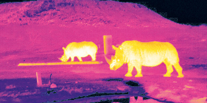
Finding and counting animals is key to this, but mainstream methods haven’t changed much since the heyday of Jane Goodall and Dian Fossey, with individuals trekking across swathes of land, pen and paper in hand. More recently, however, the discipline has been given a tech upgrade. “We fly drones with thermal imaging cameras,” said Veitch-Michaelis. “Over the last 10 years, drones have had a massive explosion in use in conservation, the reason being that drones are reasonably cheap, you can cover much more area than with a ground-based survey, and we can put the kind of instruments we want on to them.”
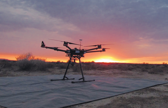
Veitch-Michaelis and his crew predominantly use multirotor drones, equipped with GPS, stabilised cameras on gimbals and autonomous flight capabilities. As many animals have evolved to camouflage themselves, thermal cameras have become an important tool, capable of penetrating jungle canopies and thick savannah grasses. The technology has even been employed by the John Moores team as a method for detecting poachers, who are adept at blending into the environments they operate in.
“The problem is that a lot of other stuff looks like poachers,” said Veitch-Michaelis. “In places like South Africa, where it gets quite warm, the sun heats objects on the ground like rocks or tree trunks, and they look the same as the bright blobs that could be mistaken for humans.”
Similar problems can occur when it comes to counting fauna. Animal waste is the same temperature as the animal itself, and this can easily lead to miscounting. Refining software to correctly label thermal images is the current major challenge.
“What we want is something… where we can take an image, put it on to computer, and have the computer label the image for us, which saves us going through thousands of images by hand,” said Veitch-Michaelis.
This is where the ‘Astro’ meets the ‘Ecology’.
“(We) realised that actually the kind of problems that ecologists were facing in image processing had already been dealt with in astronomy,” he continued. “We use a combination of what’s called citizen science and machine learning. Citizen science is a relatively new idea where you can ask the public to label your data. This is being championed by a website called Zooniverse, based in Oxfordshire. You can upload your data and provide a guide for people on how to label it, and they’ll do it for you, for nothing more than internet points and the enjoyment of doing it.”
Once a substantial number of images have been correctly labelled, these can be used to train an AI to do likewise.
“And this is really what we think the future of ecology is,” Veitch-Michaelis explained. “We want to build these systems to rapidly classify thousands of pictures… and ideally we want this running on a drone itself. So for things like anti-poaching, we want to fly around, process a live video stream and immediately alert a ranger or someone on the ground when we see a poacher.”
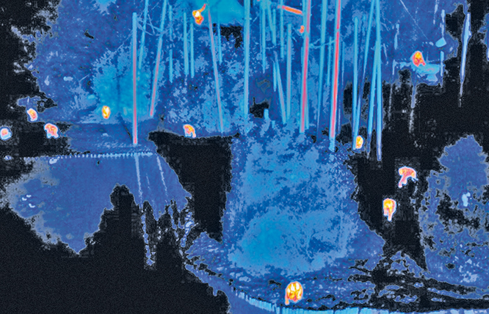
While the John Moores team has trialled its technology in relatively familiar wildlife hotspots such as Madagascar and Indonesia, another of the conference’s presenters had been further afield. Melissa Schiele is a marine ecologist at the Zoological Society of London. Using a fixed wing drone, she and her colleagues have been monitoring the waters of the Chagos Archipelago, a group of islands about 500km south of the Maldives in the Indian Ocean. “We believe that we are the first to develop a water-landing fixed-wing unit specifically designed for marine ecology, but also maritime surveillance as well,” Schiele told the audience.
The islands – also known as the British Indian Ocean Territory (BIOT) – are the subject of an international dispute between Mauritius and the UK, with the UN’s highest court recently ruling that they should be returned to the former. Apart from a US military base on the largest atoll, Diego Garcia, the Chagos are now uninhabited and were declared a marine protected area (MPA) in 2010. But with just one British vessel patrolling an area of more than 56km2, the archipelago poses conservation challenges.
“That same vessel also has to do all the scientific expeditions as well,” said Schiele. “So any solution that can increase enforcement capacity is welcomed.”
Only around 3.7 per cent of the marine protected areas (MPAs) of the world are actively managed, leaving the vast majority open to various forms of exploitation. It has been claimed that the BIOT MPA was created primarily to frustrate the sovereignty dispute, making it more difficult for displaced Chagossians to return. For now, however, the area remains protected. Fishing is usually forbidden or heavily restricted, but the lack of policing often sees this openly flouted.
“The main concern for the BIOT are south Asian vessels, specifically targeting tuna stocks and sharks for fins,” said Schiele.
Prosecuting offending ships is difficult, however, as catching fishermen with their gear in the water is rare. According to Schiele, clear pictures of boats actively fishing plus the hull identification number are the ‘holy grail’, and drones present an opportunity to obtain them.
The Chagos research took place largely from the BIOT vessel, which presented challenges. Dynamic home positioning will take a drone back to where it took off, something that becomes tricky when your launch site is the deck of a moving ship. Water landings led to seawater ingress and ecologist Schiele had a crash course in drone maintenance with several nights spent soldering into the small hours.
“We know that once the drone is fully waterproofed in the next iteration, it’s going to be a very powerful tool in ecology and surveillance as well,” she said.
What’s more, the platform is affordable. “We believe our drone…is going to be the revolutionary tool that MPA managers – potentially in developing nations – will be able to afford, as well as marine scientists on limited funding.”
MORE ON ENVIRONMENT


