Source: Chicago from the Air
Fans of Chicago (the city, not the band) will soon be treated to a unique, drone view of the Windy City with the release of the PBS film Chicago from the Air.
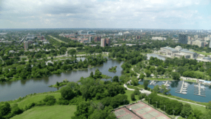
Narrated by WTTW’s Geoffrey Baer, the film will take viewers on a FPV drone flight across the cityscape.
Premiering Thursday at 7:30 p.m. on PBS affiliate WTTW, the film will “soar, swoop, dive and spiral through and around Chicago’s landmarks, neighborhoods and suburbs,” according to a production spokesperson.
A media statement notes:
“Through the lens of a high-flying drone camera, we get a breathtaking view of the city that stretches as far as the eye can see. Zoom in to trace the remnants of long-lost roads and landmarks and learn what has replaced them, discover the ways industry literally reshaped our region.”
Trails and Transit Lines by Drone
Baer—a seven-time Emmy Award-winning public television writer, producer and program host—will provide commentary the film as the drone flies over lost neighborhoods, familiar streets that were once Native American trails, and abandoned transit lines that can be seen only from the air. In addition, the film will feature noted architectural landmarks, parks, lakes and sports arenas.
“Chicago from the Air represents an extraordinary opportunity for WTTW to take our inherently curious audiences on a journey of discovery in an innovative way,” WTTW CEO Sandra Cordova Micek said.
“With this new special, we hope to foster curiosity about our great city while inspiring people of all ages to set off on their own adventures.”
Drone Film: Ultimate Social Distancing
“As we were thinking about new and exciting ways to explore Chicago, we came up with the idea to film with a drone from high above the city – the ultimate in social distancing.” Baer added.
“In this show, we not only rediscover our dramatic lakefront, iconic buildings, and parks, but we also see the heroically scaled industry and sprawling infrastructure that have transformed our region – and all from a thrilling perspective.”
Features
The film will include drone footage covering:
- “Grant Park, its connection to the Great Chicago Fire, and the department store magnate who made it possible
- A heart-stopping dive into south suburban Thornton’s 450-foot-deep limestone quarry, one of the largest in the world
- A bike trail over an abandoned rail line named for an athlete once dubbed “the world’s fastest man” who also had to overcome racist opposition for the right to compete
- Vestiges of the 1893 Chicago World’s Fair
- Visible signs of the Ice Age and a once much larger Lake Michigan
- Riverside, America’s first planned suburb, and its revolutionary winding street pattern designed by Fredrick Law Olmsted
- What lies beneath the city’s diagonal streets
- How redlining altered some parts of the landscape on Chicago’s south and west sides.”
Jason is a longstanding contributor to DroneLife with an avid interest in all things tech. He focuses on anti-drone technologies and the public safety sector; police, fire, and search and rescue.
Beginning his career as a journalist in 1996, Jason has since written and edited thousands of engaging news articles, blog posts, press releases and online content.
Email Jason
TWITTER:@JasonPReagan
Subscribe to DroneLife here.
https://dronelife.com/2020/11/18/how-a-drone-film-uncovers-a-new-view-of-chicago/


