

An insider look at DroneU and Pix4D‘s Accident Scene Reconstruction Training for Drone Operators.
The following is a Guest Post by Paul Aitken, the Chief Pilot, and co-founder of Drone U, and co-host of the popular Ask Drone U podcast.
Anyone familiar with drone mapping may understand the long list of complex nuances of acquiring and processing 3D models using aerial photography. Drone mapping may be complex, but accident scene reconstruction using drone mapping adds an entirely new level of intricacy.
With crash scene reconstruction, accuracy must be exact when court decisions weigh on the data. It now may easier to understand how difficult it would be to learn the complex workflow in a limited timeframe. But Drone U may have made learning easier by gamifying the drone training experience.
While pilots may make drone mapping flights look easy, the processing of data usually accounts for 80% of the time necessary to complete a drone map. In parallel, instruction of processing aerial images to create drone maps also accounts for a large majority of training pilots. This is where most trainings fall short. Typically, most drone training programs focus primarily on the processing of drone images to create drone maps without teaching students the practical acquisition strategy to acquire the data necessary to process these maps.
Gamifying the Training: Compete to Learn
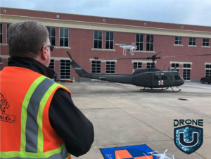
Drone U recently partnered with Pix4D to offer an accident scene reconstruction class, where drones are used to map plane and helicopter crashes. The training took place at the National Transportation Safety Board (NTSB) training academy where students had the unique opportunity to fly and map a Cessna plane crash and a helicopter crash.
In addition, students were guided through “SAR Mapping,” or drone mapping to systematically cover a search and rescue area to create orthomosaics for site command. Students were also taught how to use a new software “Loc8,” to automate the process of searching for humans in aerial photos. Practical flight based missions help gamify the experience for students to aid in increasing retention of information and enjoyment of the training experience.
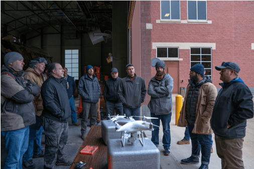
From the Classroom to the Field
Students took to the skies on the second day of training which helped ensure the realization of the relationship between acquiring data and processing data. The three flight missions helped teach students the different flight mission acquisition strategies of nadir missions and cross hatching missions versus orbital flights and free flights using extreme oblique imagery. Drone U believes that by creating real life missions, the trainings go from boring college-type lectures to real-life training experiences. Experience-based trainings help increase retention of information, engagement in the class, and long-lasting memories of practical workflow. Not to mention, most students rave of the fun they had during each drone mission.
Mission Based Learning

Mission 2: Students’ mission was to map the UH-60 Helicopter to support a damage assessment of the helicopter. The model will be viewed in a remote command post in order discern a maintenance plan for headquarters.

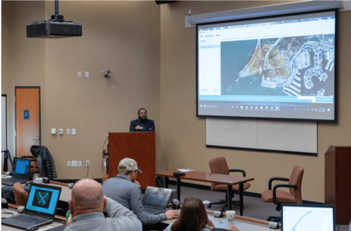
The last day of training showcased important workflow techniques for high-precision accuracy on 2D maps while also teaching students how to clean up 3D models and surfaces for orthomosaics. This processing instruction explored well beyond the typical example of how to merge maps in Pix4D. Students mastered the reconstruction workflow through multiple processing examples that showcased the importance of scale constraints in relative space to ensure the highest degree of accuracy for the crash scenes. Students finished the class with a demonstration of a new search and rescue software that autonomously scans the mapping images to search for color to find missing persons and other subjects.
Drone U’s purpose of partnering with Pix4D to host a training at the NTSB training academy is simple: provide practical training experience in addition to processing instruction to increase engagement, interaction and, above all, retention of this training material. The training provided photogrammetry processing instruction with acquisition based instruction to help students understand the importance of the relationship between acquisition of data and processing of that data. Students are challenged through each flight mission as they are competing to create the most accurate models.
It seems to be working as students are already enthusiastically proclaiming the fun they had and the depth of practical information they acquired – and the training will take place again this spring.


Miriam McNabb is the Editor-in-Chief of DRONELIFE and CEO of JobForDrones, a professional drone services marketplace, and a fascinated observer of the emerging drone industry and the regulatory environment for drones. Miriam has a degree from the University of Chicago and over 20 years of experience in high tech sales and marketing for new technologies.
Email Miriam
TWITTER:@spaldingbarker
Subscribe to DroneLife here.
https://dronelife.com/2019/02/08/gamifying-drone-training-inside-droneu-and-pix4ds-accident-scene-reconstruction-training/


