

At this week’s DroneDeploy conference, DroneDeploy co-founder Mike Winn says that despite the challenges of 2020, the future of drone mapping, and the drone community, is here.
In an opening address, Winn presented a fascinating view of the worksite of the future, using the construction industry as an example. “Almost every industry involves construction of some sort,” said Winn.
“…In many ways, those construction sites of the future will look the same: red earth, gray concrete, yellow machinery. But one thing that will be different is the workforce. The workforce will be augmented by many more drones,” said Winn.
Winn, and his company, are moving beyond the current understanding of “drones” to enhance the jobsite of the future. “These drones of course will collect data, and that data will be truly democratized,” Winn said. “Every person on the jobsite will have access to that data.”
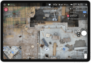
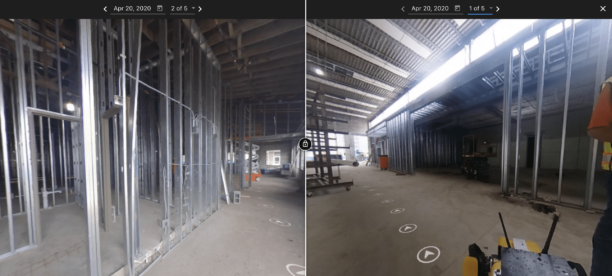
The DroneDeploy founders have built a company around the idea that making accurate, digital data available to everyone has the potential to change business entirely. In Winn’s speech at the DroneDeploy conference, it’s clear that the company is now thinking well beyond aerial photogrammetry to get data from every aspect of a site. “These drones will not only be flying…some will be driving, and some will be walking,” he said. “…They will not just operate outdoors, but indoors. They’ll be able to create digital replications of entire structures, inside and outside…and with the next generation of photogrammetry, reality will be almost perfectly captured.”
Other features offer vertical flight, elevation analysis, and more flight control. Not only are these features looking forward to new robotic tools, they’re setting up the DroneDeploy platform to be a full solution: one that can take in data from many different sources and deliver a full digital view of a worksite from one place. It’s a careful development path that continues DroneDeploy’s unwavering progress towards their goal of one button, democratized data.


Miriam McNabb is the Editor-in-Chief of DRONELIFE and CEO of JobForDrones, a professional drone services marketplace, and a fascinated observer of the emerging drone industry and the regulatory environment for drones. Miriam has penned over 3,000 articles focused on the commercial drone space and is an international speaker and recognized figure in the industry. Miriam has a degree from the University of Chicago and over 20 years of experience in high tech sales and marketing for new technologies.
For drone industry consulting or writing, Email Miriam.
TWITTER:@spaldingbarker
Subscribe to DroneLife here.
https://dronelife.com/2020/10/14/dronedeploy-conference-the-future-is-here/


