
 Read or listen to all of the headlines in one place: excerpts from the DRONELIFE drone news of the week October 21. Click on the titles below for the full story. This week we were covering mapping and GIS conference INTERGEO and INTERAERIAL SOLUTIONS in Essen, Germany. See all the latest from the global drone industry.
Continue reading below, or listen:
..Some challenges to starting a drone program include internal resistance from leadership, lack of internal alignment with other teams, and the overall learning curve associated with the use of new technologies on a large scale. The success of a drone program is tied to alignment; it is critical to get your key stakeholders engaged early in the process, both from a leadership perspective all the way down to boots on the ground—your team must be a part of the solution set. If you don’t do that, you’re not going to be successful.Additionally, once your organization sees tangible results from your drone program, teams will want to scale the program rapidly; it’s crucial to set up your business operations, infrastructure, and processes in a way in which they are capable of handling a rapid scaling rate.
Volatus Acquires Synergy Aviation: More than 500,000 km of Pipeline Right of Way Surveillance
Volatus Aerospace announced that it has signed an agreement to acquire Synergy Aviation, a move that will strengthen Volatus’ position in the oil and gas industry in Western Canada. An industry leader in aerial surveillance, pipeline integrity monitoring, and specialized geomatics, Synergy Aviation patrols and inspects over 500,000 KM of pipeline, providing Canada’s oil & gas sector with reliable and comprehensive right-of-way integrity data. The combination of Synergy’s industry leadership with Volatus’ drone technology solutions will give Volatus a major edge in introducing new remotely operated drone solutions to meet regulatory and asset monitoring needs.
The BRINC Ball is Changing Outcomes in Crises for Police and First Responders
Now, the company has gone beyond drone hardware to help their customers with the BRINC Ball – a communications tool enclosed in a nearly indestructable ball form, one that can be thrown into a suspect’s environment, or into the rubble of a damaged building to communicate with survivors. The company describes the BRINC Ball as a “next gen throw phone.” Whatever you call it, it’s incredibly effective.
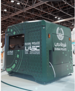 Dubai Police Introduce Drone-in-a-Box for Faster Response to Community
At the recent GITEX, Dubai’s globally renowned technology show, the Dubai Police introduced a new drone-in-a-box solution for faster response to accidents and requests for assistance. The system is evidently an Airobotics system. Recently acquired by Ondas Holdings, Airobotics was one of the first autonomous drone systems on the market, receiving the world’s first authorization for totally autonomous drone flight in 2017. Since then, their large, heavy duty aircraft and dock have been implemented in military, port surveillance, mining and other heavy industry around the globe. As innovators in totally autonomous, remotely operated drone flight, Airobotics was named a World Tech Pioneer in 2019.
Quantum Systems Funding: New Investors for Advanced eVTOL
Unmanned Aerial Systems (UAS) specialist Quantum-Systems has announced the closing of a financing round with new investors Peter Thiel, Project A, and Sanno Capital. The round also saw participation from existing investor Bayern Kapital. With its industry-leading electric vertical take-off and landing (eVTOL) systems, Quantum-Systems has customers in both the public and private sectors relying on its versatile UAS for security, defense, humanitarian, and geospatial operations.
Unmanned aerial vehicle (UAV) drone data collection company Soaring Eagle Technologies has received one of the first BVLOS Federal Aviation Administration (FAA) waivers authorizing the deployment of small Unmanned Aerial System (sUAS) commercial inspection missions following operational guidelines, as opposed to specific operations in limited geographical areas. The new nationwide approval is based on meeting operational parameters, rather than being restricted to certain areas within specific time limits. Clients of Soaring Eagle Technologies will now be able to gather data such as high-resolution images or LiDAR with greater speed and security than would be possible using manned aviation.
From the Floor of Intergeo: Amuse Oneself, Green Light LiDAR for Aquatic Applications
The 10-year old Amuse Oneself makes the TDOT GREEN lightweight LiDAR solution designed to be carried on a commercial, off the shelf aircraft or the company’s proprietary gas and electric hybrid drone, featuring a 2 hour flight endurance appropriate for long-range missions. TDOT GREEN is a drone-mountable laser scanner system using green light, which is not easily absorbed by water. Delivering 60,000 pulses of laser per second toward the ground, the TDOT green can penetrate between 5 – 10 meters of water: the company is developing solutions that should increase the effective depth to 30 – 40 meters
Volatus Acquires iRed Remote Sensing: Thermographic Survey
Volatus Aerospace announced its signing of an arm’s length definitive agreement to acquire Emsworth, England-based drone services and training company iRed Limited. iRed began as an infrared technologies, training, and services specialist at the time of its founding in 2001. While maintaining these specialties, the company expanded into a range of drone related services, equipment sales, and a diversified customer base.
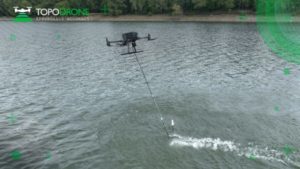 TOPODRONE Launches AQUAMAPPER: Airborne Bathymetric Surveying Solution
At global mapping show INTERGEO this week, LiDAR equipment company TOPODRONE has launched AQUAMAPPER, a UAV-based solution for bathymetric surveying and marine construction. Bathymetric surveying is the underwater equivalent of topographic surveying, mapping the floor of rivers, lakes and oceans. The new multitasking data collecting device has been successfully deployed alongside TOPODRONE LiDAR ULTRA equipment for the airborne surveying of a Romanian highway construction project in order to provide a digital twin of a scanned area.
Understanding the regulations, and the responsibilities of individual member states, is important for drone manufacturers. Get it right, and EASA aircraft certification enables business with all European member states: the first EASA certifications are being granted now. Get it wrong, and you may end up with an aircraft that isn’t approved for the applications it was designed for. Michael O’Sullivan, AgEagle’s Chief Commercial Officer, told DRONELIFE that the regulations help guide product development and the R&D roadmap for AgEagle’s drone solutions. By working backwards from the regulations, O’Sullivan explains, manufacturers can tailor a solution to meet the specifications of the client’s use case – and is legal to fly in the region or country where they reside.
Enabling Small Drone Fleets: SkyHopper Micro is a Miniature, Lightweight Data Link
Cybersecurity and drone smart solutions provider Mobilicom Limited has extended the range of its line of SkyHopper data links with the release of a micro bi-directional model developed to allow mass deployment of small drone fleets. Developed alongside small-drone Tier-1 manufacturers, the NDAA-compliant SkyHopper Micro fulfills an increasing demand for high-use applications like commercial inspections, disaster relief and defense intelligence or loitering drones.
Drone Tools for the Roofing Industry: EagleView Assess
Geospatial technology leader EagleView announced today the launch of EagleView Assess, an autonomous drone technology solution granting residential property intelligence. The solution features optimal resolution imagery, along with anomaly detection and roof measurement. EagleView Assess gives contractors, adjusters, and insurance carriers access to unbiased evidence of roof damage, and autonomously launches from the ground without the need for a pilot. The combination of autonomy and property intelligence streamlines the claims process, expediting claim acceptance and repairs. Currently in use by industry leaders in Insurance, contractors will be able to join the waitlist for EagleView Assess starting today.
European Drone Forum Kicks off on November 7-8 in Cologne, Germany
The European Drone Forum is more than 10 years old, and designed to help its members grow their businesses and better serve their customers by partnering with other companies and the government organizations that regulate them. The European Drone Forum will present upcoming regulations, reports on operational experiences, and the challenges and opportunities facing the drone industry in Europe today. The show is presented in cooperation with the European Union Aviation Safety Agency (EASA) and the German Federal Ministry for Digital and Transport.
Miriam McNabb is the Editor-in-Chief of DRONELIFE and CEO of JobForDrones, a professional drone services marketplace, and a fascinated observer of the emerging drone industry and the regulatory environment for drones. Miriam has penned over 3,000 articles focused on the commercial drone space and is an international speaker and recognized figure in the industry. Miriam has a degree from the University of Chicago and over 20 years of experience in high tech sales and marketing for new technologies.
For drone industry consulting or writing, Email Miriam.
TWITTER:@spaldingbarker
Subscribe to DroneLife here.
https://dronelife.com/2022/10/21/drone-news-of-the-week-october-21-dronelife-headlines-all-in-one-place-to-read-or-listen/


