

Continue reading below, or listen:
TEKEVER Adds GAMASAR to AR5 UAS: Detecting Objects in Any Weather Conditions
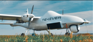
Unmanned aerial systems leader TEKEVER has announced the addition of GAMASAR to its AR5 UAS. A Synthetic Aperture Radar (SAR) developed by TEKEVER’s Space division, GAMASAR is available on both AR5 and AR3 systems to support maritime and land missions with its ability to detect multiple types of objects in all-weather conditions.
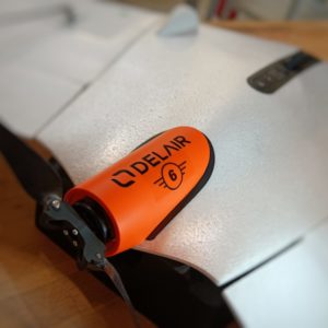

French drone manufacturer DELAIR has released the C6 class UX11 drone, enabling BVLOS operations across Europe without the need for specific authorization within the framework of the EASA European standard scenario STS-02. The UX11 is the first ever C6 class drone available in Europe.
BRINC in Turkey: Responding in Crisis
BRINC Chief of Staff Andrew Coté had arrived from Turkey only hours earlier when we met at the BRINC facility in Seattle, but the former Marine brought the same calm efficiency to our interview as he had in the previous days amid the post-earthquake devastation he found in the Hatay Province, as he and Chief Pilot Chase Bailey spent four days flying during all available daylight hours to search for survivors and remains.
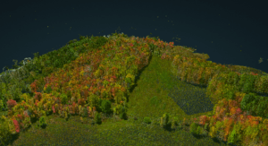

Light Detection and Ranging (Lidar) imagery offers high resolution models of ground elevation, with vertical accuracy. As Lidar sensors have gotten smaller and lighter for use on drones, the use cases have expanded. Lidar imagery is flexible and precise, which makes it useful for professionals who want to understand a surface
Skydio Funding: $230 Million to Expand U.S. Manufacturing, Hiring
US drone manufacturer Skydio funding soars by $230 million for a total of over $562 million.
From the Skydio funding announcement: The $230 million Series E round brings Skydio’s total funding raised to $562 million with a current valuation of over $2.2 billion. Linse Capital led the round, joined by existing investors Andreessen Horowitz, Next47, IVP, DoCoMo, NVIDIA, the Walton Family Foundation and UP.Partners. Skydio also welcomed new investors Hercules Capital and Axon, a technology leader in global public safety and a key Skydio technology partner.

An Yves St. Laurent (YSL) carbon offset project in Morocco.
GLOBHE on Monitoring Carbon Offset Projects Around the World
GLOBHE is the impact tech company behind the crowd-droning concept and the largest album of drone-collected images in the world. With a network of local drone operators in more than 130 countries, GLOBHE enables stakeholders from anywhere to monitor and understand places and projectsaround the world.
For nature-based carbon offset projects, that monitoring offers tremendous value.
Inside the Drone Mission to Study Volcanos: Autel’s EVO Lite+ on Irazú
An international team of scientists has deployed an Autel Robotics drone to monitor activities on Costa Rica’s Irazú Volcano.
Selected for its high-quality sensor and durability, the Autel EVO Lite+ drone served as the perfect solution for conducting research using an Unmanned Aerial Vehicle (UAV). Operable in conditions with up to 37 knot winds, the EVO Lite+ flew safely through 17 knots. The drone was operated by certified FAA Part 107 Remote Pilot Ian Godfrey, who is SINAC Certified for UAS (Unmanned Aircraft System) operations in National Parks. The team successfully collected data and applauded the drone’s performance in spite of the high altitude volcanic environment and windy conditions.
Public Safety Drone Review, Tuesday March 7: BRINC Drones, Airobotics, and More
Don’t miss the March 7 episode of the Public Safety Drone Review, presented by DRONERESPONDERS and DRONELIFE, with guests from BRINC Drones and Airobotics! The Public Safety Drone Review is a new monthly resource for the public safety community. This free event will be held live on March 7, 2023 at 3pm EST: and on the first Tuesday afternoon of each month going forward. Register here for the live webcast, or watch later on the DRONELIFE TV YouTube channel
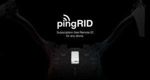

uAvionix has announced the launch of pingRID, a Remote ID Broadcast module for drones. Compact and easily attached, the aviation-grade transmitter is the quickest and easiest way for drone operators to comply with the FAA’s Part 89 Remote ID standards. “The Remote ID rule is a key part of the FAA’s commitment to safely integrate uncrewed aircraft into the National Airspace System and uAvionix is pleased to apply its avionics experience by delivering a product that meets the FAA’s requirements without sacrificing the drone operators’ time or aircraft performance,” said uAvionix CEO Paul Beard, an Academy of Model Aeronautics Hall of Famer. “A license plate for your drone needn’t be complex or require an application to run and with pingRID, you simply charge, attach and fly – it’s that easy.”
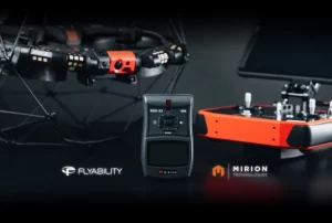

Swiss drone company Flyability has announced its collaboration with Mirion Technologies, a leading provider of radiation detection, measurement, analysis, and monitoring solutions. The new agreement will see the integration of the Mirion RDS-32™ radiation survey meter into Flyability’s Elios 3 indoor drone, enabling nuclear operators to collect accurate radiation data remotely and allowing nuclear personnel to remain safely outside of irradiated areas during data collection. This data will be available both during flight and afterward, for post-processing.
How Fast is the Open Source Drone Ecosystem Growing? Dronecode Publishes Year in Review
As the drone industry grows and new manufacturers enter the market, is the use of open source drone platforms growing? The Dronecode Foundation, the organizing force behind the PX4 open source drone ecosystem, has published their Year in Review report for 2022: and the metrics tell an interesting story
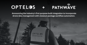

Today, visual data management and analysis software supplier Optelos and job site software provider Pathwaveannounced a technology partnership enabling carriers, asset owners and contractors to combine drone data captures and digital twins with safety compliance and closeout data in order to automate and document the complete tower inspection process.
Athena AI, Teal 2 Drone: Computer Vision to Identify Weapons, Friends and Foes at Night
Military technology company Red Cat Holdings has announced Athena AI as a computer vision partner for its Teal 2 military-grade drone. Military decision-support company Athena has licensed its proprietary computer vision architecture to Red Cat, which enables high-speed tracking of objects and in-depth data exploitation at slower speeds. Athena’s solution is capable of identifying weapons, objects and poses at night, as well as Identification Friend or Foe (IFF) markers like Cyalume HALOs and IR beacons.

“It just wouldn’t be a BRINC demo without some broken glass,” joked BRINC Founder and CEO Blake Resnick, as an audience of customers and media outlets watched the new LEMUR 2 for law enforcement and SWAT operations break through a plate of glass with the glass breaking attachment that allows the LEMUR 2 to enter a building.


Miriam McNabb is the Editor-in-Chief of DRONELIFE and CEO of JobForDrones, a professional drone services marketplace, and a fascinated observer of the emerging drone industry and the regulatory environment for drones. Miriam has penned over 3,000 articles focused on the commercial drone space and is an international speaker and recognized figure in the industry. Miriam has a degree from the University of Chicago and over 20 years of experience in high tech sales and marketing for new technologies.
For drone industry consulting or writing, Email Miriam.
TWITTER:@spaldingbarker
Subscribe to DroneLife here.
https://dronelife.com/2023/03/03/drone-news-of-the-week-march-3-dronelife-headlines-all-in-one-place-to-read-or-listen/


