Battlefields entered a new era with the introduction of small unmanned aerial vehicles, or sUAVs. Commonly called drones, sUAVs enable soldiers to gain an aerial view of the battlefield and improve their situational awareness of the battlespace.
Designed for low-altitude intelligence, surveillance and reconnaissance missions that depend on rapid deployment and agile maneuverability, sUAVs are being pushed to add more technology while also being asked to fly farther, smarter and better.
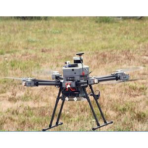
It’s a situation that’s challenging the developer community, according to Won Kim, a program manager at Draper. His team is unveiling a new set of capabilities for sUAVs that represents an advance in the platform from remotely operated vehicles to those capable of fully autonomous operations.
One new capability is to equip sUAVs so that they can fly ahead of a military unit to scout a location and sense the presence of chemical, biological, radiological and nuclear (CBRN) elements. Hazard detection using an sUAV can reduce the kinds of risks soldiers might encounter by scouting a location using handheld or vehicle-mounted sensors.
“Customers are asking, can an sUAV sniff out these CBRN hazards in place of humans? How smart does an sUAV need to be to search, map and locate these CBRN hazard without a remote operator? When an sUAV encounters a building or obstacle, can it fly in and around it safely? These are just some of the questions our team is exploring,” Kim said.
Kim’s team set to work on these challenges in a program funded by the Joint Program Executive Office for Chemical, Biological, Radiological and Nuclear Defense (JPEO-CBRND) called CSIRP, which stands for CBRN Sensor Integration on Robotics Platform. The team investigated the customer needs through field observations, noting requirements such as sensor efficiency and resolution, flight speed, height, duration, autonomous operation, sensor-driven mapping, networked command and enhanced situational awareness through shared interactive digital maps.
Soldiers operating in urban environments, for instance, need an sUAV that can navigate in and around buildings and obstacles, such as trees or vehicles even when GPS signals are degraded or completely unavailable. Soldiers also need sUAVs to remotely search, detect, map and locate dangerous CBRN hazards. Soldiers dispersed across an area also want a way to share information that is secure, networked and mapped to the environment.
The new capabilities Draper developed for CSIRP take advantage of multiple environmental inputs, along with a sensor fusion algorithm that can synthesize data from instruments including GPS, LiDAR, inertial measurement units, magnetometers and cameras. All that fused information is designed to achieve robust and autonomous operation through the use of new algorithms developed for CSIRP that make the sUAV capable of obstacle detection and avoidance.
Under CSIRP, Draper integrated the sUAV with a mobile computing app, running on a handheld device, called the Tactical Assault Kit (TAK), which gives soldiers a map-based common operating picture on a shared network and provides enhanced situational awareness for command and control. Draper has developed software for every version TAK and the CBRN sensor plugin since it was first developed by the Department of Defense.
In a series of field tests, Draper engineers set the sUAV on a path of several miles, over and around obstacles, navigating autonomously until it detected a simulated CBRN hazard and conducted a sweep of a field one square kilometer in size to map elements of interest. The information was gathered onboard the UAV and shared with the TAK operator and users in the network, including headquarters.
“Mobile military technologies, like sUAVs, can be force multipliers and force protectors at the same time,” Kim said. “Anytime you can deploy technology like an sUAV to detect suspected CBRN hazards remotely and operate independently without exposing a soldier unnecessarily to harm is an advance in warfighter systems, and that’s important to us at Draper.”
“Draper designed the autonomy framework and sensor-driven mapping algorithm to be an extensible, modular and resilient mobility platform that is vehicle and processing system agnostic,” said Julius Rose, associate director for Sensors and Delivery at Draper. “As new capabilities and vehicles are developed, autonomous systems should be readily adaptable to support numerous mission types across domains, be that air, ground or sea. Development needs to be efficient, reusable and agile to keep up with the pace of the needs of soldiers and personnel in the field.”
Draper’s work on the CSIRP program builds on its legacy in autonomous systems, algorithms and positioning, navigation and timing. Advances made through the program will be applied to other air systems, as well as ground, marine and underwater systems. In addition to working with autonomous systems, Draper has assisted U.S. government agencies with projects including cybersecurity, technology protection and miniature cryptography for high stress environments.