Cave Explorer Drone Could Search for Life on Mars
Matthew Greenwood posted on April 08, 2019 |
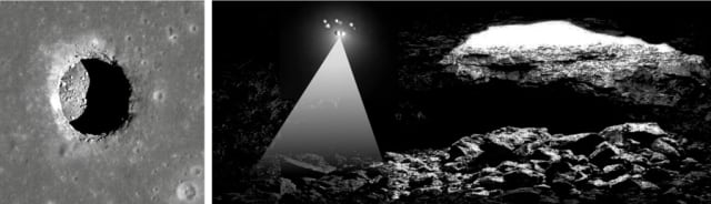
NASA and the SETI Institute are working on a drone that could explore, map and analyze caves under the Martian surface to find evidence of life on the planet.
The flying drone recently created a 3D map of a cave in Iceland using LIDAR technology. The cave, created by flowing lava, is similar to caves on the lunar and Martian surfaces. Developers believe the technology could realistically be adapted to explore those caves. The research was presented at the recent Lunar and Planetary Science Conference.
“Small free-flying spacecraft might be the ideal robotic platform for the exploration of lava tubes on Earth, the Moon, and Mars for the simple reason that they would not need to come in direct contact with any of the rough and potentially unstable surfaces found inside caves and lava tubes,” said Andrew Horchler, Director of Future Missions and Technology at Astrobotic, the robotics company that partnered with the SETI Institute for this project. “Nimble drones could enter, map, and exit caves quickly, returning from the darkness to send data back to Earth, return a sample to the surface, recharge, and refuel.”
However, the drone would need to be able to navigate on Mars’ thin atmosphere—and the moon’s complete lack of atmosphere—where a conventional quadrotor drone couldn’t function. Small thrusters may be the solution.
The Lofthellir Ice Cave mission tested the idea of using a LIDAR-equipped drone to safely navigate and accurately map rock and ice inside a dark lava tube without GPS or an existing map to guide it. Astrobotic has developed a custom navigation software called AstroNavto enable small crafts like drones to autonomously explore underground environments. It uses both stereo vision and LIDAR, meaning the LIDAR can be used to explore environments in complete darkness while the visual sensor can aid navigation in lighted areas. The drone can switch between these modes in mid-flight.
Drone maps lava tube in Iceland—and could someday map terrain on Mars.
“The Astrobotic drone and LIDAR performed exactly as we had hoped, and was able to help us map the Lofthellir Lava Tube in 3D within minutes,” said Pascal Lee, a scientist at SETI.
The successful Iceland test showcases the project’s potential for future exploration on other worlds, where drones could create 3D maps that would help mission planners prepare crewed missions to Mars. They could also search for signs of water.
“More development work will be needed to create a system that’s ready for the Moon or Mars, but the study of this icy lava tube is an important first step for us,” said Horchler.
Read more about technologies for Martian exploration at YES! NASA’s InSight Landed on Mars. Here’s What’s Next.


