

Today wraps up fourth annual InterDrone Conference where the drone industry comes together to learn from and share ideas with one another. With so many members of the drone industry present, InterDrone is the perfect stage to break news and make announcements. Over 130 drone manufacturers, sellers, and solution providers filled the expo floor at the Rio Hotel in Las Vegas.
There were many announcements made at InterDrone this year, but here are the ones that most caught our ear.
1. Yunnee’s joint venture with 3DR and release of all-new E10T dual thermal imaging camera
Yuneec and 3DR, two founding members of the Dronecode software consortium, announced a U.S.-headquartered joint venture to bring products based on the Dronecode platform to market. 3DR Government Services expertise in software and Yuneec’s hardware mastery and manufacturing scale make this an ideal joining. Together, these two companies will serve the U.S. government and their vendors in the construction and engineering industries, addressing their security and open platform needs. The first product from 3DR Government Services is the Yuneec 3DR H520-G, which was unveiled at the InterDrone Conference in Las Vegas this week.
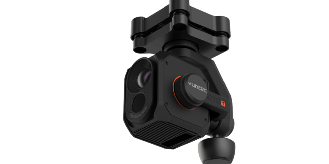
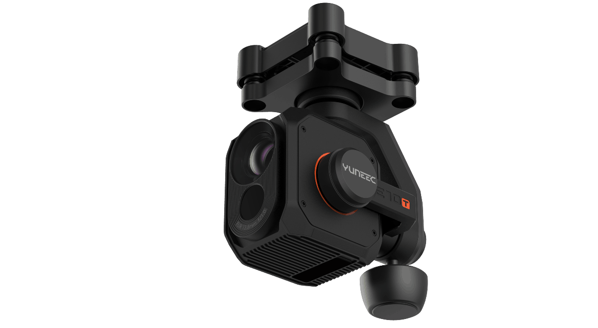
Yuneec also announced the expansion of its commercial UAV payload offering with the unveiling of the all-new E10T, an advanced thermal camera for commercial applications. The E10T is an all-in-one, three-axis gimbal, dual thermal imaging and residual light camera available in two versions with different lens options: 320 by 256-pixel or 640 by 512-pixel thermal resolution. The H520-E10T system was specially developed for inspection, safety and search & rescue applications.

We stopped by Yuneec’s booth in the InterDrone exhibit hall to talk to Ryan Borders, Chief Operating Officer at Yuneec, about the E10T:
We’ve had a lower resolution thermal imaging low-light camera in the past. The E10T is the next generation of that, which is the high resolution. It’s going to be offered in two different flavors. One is a 320×256 and the other one is a 640×512. Both offer both low-light camera and thermal imaging camera, so they’re essentially a dual camera. You can film or take images in either or, or you can overlap them—you can do thermal imaging and overlap that with the low-light image.
—Ryan Borders, Chief Operating Officer, Yuneec
2. Parrot reveals two new drones—the Ebee X and the ANAFI Work
Launched with the promise that “it’s not about the drone,” but instead about overcoming business challenges, the Ebbe X and ANAFI Work offer highly accurate insights, whatever the user’s level of drone experience and budget.
More than the drones themselves however, what’s key is that these end-to-end solutions are built upon the commercial knowledge of the entire Parrot Group, providing professionals at all levels with a means to improve their business results-by boosting efficiency, reducing costs, improving worker safety and providing the insights needed to take better decisions.
—Gilles Labossière, Parrot Group, Executive Vice President and COO; senseFly, CEO
The senseFly eBee X is a fixed-wing drone with a design tailored to the needs of mapping and geospatial professionals. This enterprise-grade solution offers a camera to suit every job, the accuracy and coverage capabilities to meet the requirements of even the most demanding projects and is durable enough to work virtually every site.
ANAFI Work is a 4K ultra-compact drone solution for everyday business use by construction professionals, independent contractors, site managers, architects, creative agencies and more. Based on Parrot’s highly-acclaimed ANAFI drone (launched in June 2018), this highly capable, advanced imaging tool makes it easy and safe, to inspect those hard to reach areas of buildings.


3. SkyWatch.AI partners/integrates with three leading drone software providers
At the conference, SkyWatch.AI announced three major partnerships and integrations with leading drone software providers: DroneDeploy, Drone Harmony, and Maps Made Easy. Pilots will be able to purchase SkyWatch.AI’s on-demand insurance precisely for the mission they are planning seamlessly from within the flight apps they’re using associated with any of these three companies.
Drone pilots can purchase SkyWatch.AI insurance directly from Drone Deploy’s dashboard, the Drone Harmony Planner app, or the Map Pilot mobile app. Additionally, the flight telemetry is uploaded to the SkyWatch platform to analyze flight risk, and pilots are rewarded with lower insurance rates for practicing safe flight. See how this works for Map Pilot pilots in the video below.
4. Women in Drones announces their “Women to Watch” list
The Women in Drones Luncheon included an impressive panel of female business owners, drone pilots, executives, and engineers. Before the panel opened up for discussion, Suzanne Lemieux, UAS Lead and Manager, API and Sharon Rossmark, CEO and Founder, Women and Drones announced their “Women to Watch” list. And the winners are:
- Fiona Lake, Agricultural Photography, FionaLake.com.au
- Dale McErlean, Airspace Integration, Ntsu Aviation Solutions (Pty) Ltd.
- Heather Hasper, Aviation Planning, DHJ Alaska
- Jackie Dujmovic, Conservation, Hover UAV
- Marjorie Ferrone, Entertainment & Education, Drone Parks Worldwide
- Jessica Chosid, Infrastructure, Reign Maker
- Gail Orenstein, Journalism
- Sonal Baid, Product Development, Kittyhawk
- Brooke Tapsall, Safety Technology, DroneALERT
- Gemma Alcock, Search & Rescue, SkyBound Rescuer
Learn more about the winners on the official Women and Drones 2018 “Women to Watch” list.
5. PrecisionHawk Acquires HAZON and InspecTools
On day one of InterDrone 2018, Michael Chasen, CEO of Precision Hawk, delivered a keynote, during which he announced that his company had acquired HAZON and InspecTools. These businesses specialize in the delivery of inspection services and technology for the energy industry and bring demonstrated domain expertise to enable tighter integration between the collection and the analysis of drone data. During the keynote, Chasen expressed his belief that these acquisitions will help elevate the drone industry.
While PrecisionHawk has been working with a number of companies in the energy and utility space, as a company we had to get a deeper level of expertise to help elevate these conversations we’re having before we take the technology to the next level. So, this morning, I am pleased to say that we announce PrecisionHawk has acquired [HAZON and InspecTools], two of the leading companies in the drone energy and renewal space that we believe will be better able to support this industry that is rapidly looking to deploy drone technology.
—Michael Chasen, CEO of Precision Hawk
HAZON brings extensive aviation experience, standards-based operating procedures, certified drone flight operations, and inspection services, widely regarded as the best in the energy industry, to the PrecisionHawk team. The company has delivered over 13,000 inspections totaling over 8,000 hours of flight time, with a majority focused in energy markets for Fortune 500 utilities.
InspecTools brings high-fidelity machine vision software and data analysis tools built for the renewable energy market. Their market-leading software for both solar panel and wind turbine inspection is utilized by some of the largest equipment manufacturers and service providers in the world. Customers like Vestas, PG&E, and SMA Solar rely on InspecTools’ sophisticated reporting, analytics and machine learning capabilities.
6. AirMap partners with DroneInsurance.com
A final announcement made at InterDrone we want to fill you in on is the partnership between AirMap, the world’s leading airspace management platform for drones, and DroneInsurance.com, a digital drone insurance portal. Now, U.S.-based drone operators can purchase insurance from DroneInsurance.com within the AirMap for Drones mobile app, available in the App Store and Google Play.
AirMap is improving the daily flying experience for drone operators with DroneInsurance.com’s digital platform, which aims to provide a smart and paperless drone insurance experience that offers dynamic policy options to address the unique risks, pain points and insurance needs of commercial drone operators. As regulations evolve, and companies utilize drones to perform commercial tasks—from industrial inspection, to real estate photography, to remote sensing—AirMap is focused on establishing a future for drones that is safe, connected, and protected. Providing simple, in-app access to insurance solutions is another step towards achieving this goal.
What announcements were you most excited to hear about during InterDrone 2018? Let us know on our community forum.


Isabella Gustave
Digital Marketing Manager
Isabella is a digital marketing expert who creates knock-out strategies for building web presence and online communities. She has held a variety of roles including copy editor, writer, content creator, and marketing manager and has received awards for her work from the American Advertising Federation and the Society of Technical Communication. Isabella has a BA in English from the University of Florida and a MA in Technical Communication from the University of Central Florida, where she graduated magna cum laude. Outside of work, she enjoys time with her husband, labradoodle, and tabby cat.
https://uavcoach.com/interdrone-2018-announcements/


