It’s been a big year for Airobotics. The Israeli company which is the best known fully automated drone solution in the world has received a major funding boost; opened a U.S. facility in Scottsdale, Arizona; and added major new functionality to their solution – a drone solutions that does not require a human operator for flight.
The solution already has major customers in security, infrastructure and mining. The new LiDAR capabilities will expand their scope even further. LiDAR – Light Detection and Ranging – is a remote sensing method for measurement that allows for the creation of extremely detailed 3D modeling and precise surveying.
The following is taken from an Airobotics press release:
…Airobotics, the only commercial drone solution worldwide permitted to fly without a human operator, also announced the introduction of LiDAR capabilities, which until a few years ago was only possible with an aircraft as the sensors were hefty and required manual data processing. Today, LiDAR images are captured and processed quickly in the cloud, allowing Airobotics’ customers to make effective decisions based on high-frequency, consistent data capture.
Airobotics’ LiDAR capabilities provides rapid precision scans across the value chain for industries such as mining and construction. Applications typically involve tailing dams monitoring, infrastructure inspections, haul road safety compliance, stockpiles volume analytics, tracking rehabilitation progress, and more.
The use of LiDAR significantly reduces the time it takes for aerial data to be collected, even at night or in low light, and allows for rapid turn-around time on data processing. Airobotics’ drones can work with various payloads. In addition to LiDAR, spatial data can also be captured using photogrammetry, video, and infra-red (thermal).
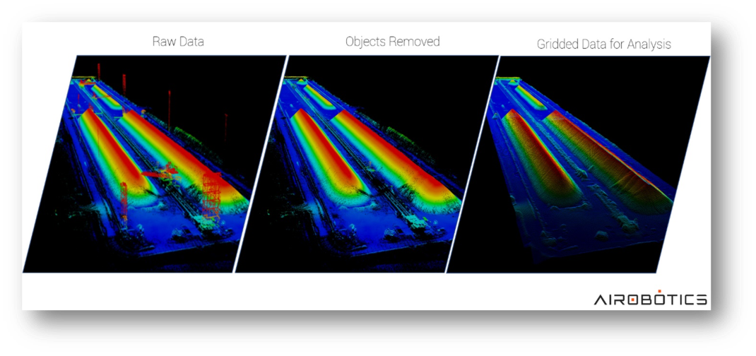
This LiDAR elevation model of a stockpile at a mining site was generated using an Optimus drone flight. After collecting raw data using LiDAR, professionals are able to remove above-the-ground information, such as heavy machinery, vegetation and people without having to physically remove them. Ultimately, this allows for access to proper data scans of the areas.
“This past year has seen a huge period of growth for us,” said Airobotics CEO and Co-Founder, Ran Krauss. “As we expand our services and shift our base of operations to the US, we continue to push advancements in autonomous drone operations, global regulatory approvals and new technology.”
…Airobotics’ automated solution represents the next generation of drone operations, overtaking standard piloted services which can be prohibitive, imprecise and not always available.
Miriam McNabb is the Editor-in-Chief of DRONELIFE and CEO of JobForDrones, a professional drone services marketplace, and a fascinated observer of the emerging drone industry and the regulatory environment for drones. Miriam has a degree from the University of Chicago and over 20 years of experience in high tech sales and marketing for new technologies.
Email Miriam
TWITTER:@spaldingbarker
Subscribe to DroneLife here.
https://dronelife.com/2019/01/30/airobotics-automated-drones-add-lidar-for-expanded-commercial-applications/


