 Firms partner to provide software, app ease & automate surveying, infrastructure-mapping and inspection
The Chinese drone powerhouse target=”_blank”> target=”_blank”> target=”_blank”> target=”_blank”> target=”_blank”> target=”_blank”>DJI and Datumate, a developer of geomatics software, are offering a drone, software and app package that automates and expedites site surveys.
The DJI-Datumate Site Survey Solution is targeted at professionals that want to simplify surveying and mapping processes, while maintaining accuracy.
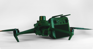
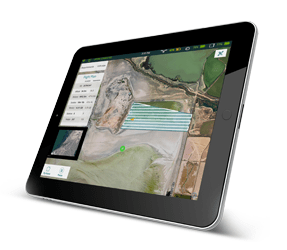
The DJI-Datumate Site Survey Solution is a comprehensive and professional package of imagery and mapping tools that help surveying, construction, inspection and infrastructure companies quickly generate a working model, site visualization, analytics and plan. The solution includes “Triple D” bundles of DJI Drone, DatuFly™ tablet app for an automated and expeditious aerial photography, as well as DatuGram™ 3D photogrammetry software that converts aerial and ground images to high-precision, geo-referenced 2D maps and 3D models.
“New drone regulations expedite the adoption of drones in a wide range of surveying related applications,” said Paul Xu, DJI’s director of enterprise solutions. “We believe that DJI-Datumate Site Survey Solutions offer a professional and cost-effective end-to-end solution for the surveying, infrastructure-mapping and inspection markets.”
DatuFly™ software generates a flight and image-taking plan for the DJI Drone, based on the best practice requirements of DatuGram™ 3D photogrammetry, ensuring survey-grade accuracy, high quality and quick results.
“We are excited to partner with DJI to automate and digitize the entire field-to-plan process. Our mutual solution brings site visualization and analytics quickly to the office, keeping field and office work effortless and safe,” said Datumate CEO Tal Meirzon. “DJI-Datumate Site Survey Solutions are an important step forward in professional surveying, construction infrastructure-mapping and assets inspection.”
DJI — Datumate Site Survey Solutions are available globally from the DJI online store, as well as through DJI and Datumate dealers.