12:40 am
crowd sourced platforms, Drone, drone mapping, Drone News, Drone News Feeds, Navigate Data Vault, News
Navigate Data Vault Allows Drone Users to Upload Images for Rewards by DRONELIFE Staff Writer Ian M. Crosby Data contribution and app creation platform Navigate has opened its first Data Vault, providing a global audience of drone users with the ability to upload their drone data and gain rewards in …
Read More »
6:01 pm
Blue Marble, Drone, drone mapping, drone mapping apps, Drone News, Drone News Feeds, Global Mapper Mobile, News, Sponsored Content
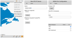
Introducing Global Mapper Mobile’s New GNSS Device Support via TCP/IP Communication Global Mapper Pro is a powerful geospatial data analysis program that contains tools for everything from raster image processing to photogrammetric point cloud creation with the Pixels to Points tool. Designed to work alongside Global Mapper Pro, the free …
Read More »
1:42 pm
Drone, drone mapping, Drone News, Drone News Feeds, drone reality capture, DroneDeploy, DroneDeploy conference, News, robotic reality capture
Reality capture is the name of the game for industries all over the world – and at the DroneDeploy Conference 2022, held in Dallas on October 6 – 7, industry leaders from DroneDeploy’s global customer base will discuss how it’s done. DroneDeploy was one of the first drone mapping platforms …
Read More »
2:58 pm
Blue Marble Graphics, Drone, drone mapping, Drone News, Drone News Feeds, Global Mapper Mobile, Global Mapper Mobile Pro, News
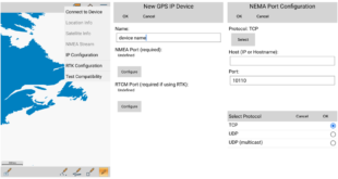
Introducing Global Mapper Mobile’s New GNSS Device Support via TCP/IP Communication Global Mapper Pro is a powerful geospatial data analysis program that contains tools for everything from raster image processing to photogrammetric point cloud creation with the Pixels to Points tool. Designed to work alongside Global Mapper Pro, the free …
Read More »
12:23 am
correlator3d, Drone, drone mapping, Drone News, Drone News Feeds, News, Phase One IIQ, SimActive
SimActive and Phase One IIQ Announce Integration in Correlator 3D Version 9.2 SimActive Inc.’s Correlator 3D photogrammetry software is designed for large mapping projects. Phase One, a pioneer of digital imaging sensors and airborne systems, are a leading tool for data capture. Now, SimActive and Phase One have partnered on …
Read More »
10:32 pm
Drone, Drone Ecosystem, drone entrepreneurs, Drone Industry, drone mapping, Drone News Feeds, Drone Software, DroneDeploy, News
CEO and Co-Founder of DroneDeploy Mike Winn has been named to SF Business Journal’s 40 Under 40 List – quite an achievement in Silicon Valley. It’s a well-deserved honor for the person who has successfully steered one of the first drone mapping companies through the upheavals of the last 9 …
Read More »
9:42 pm
DL Exclusive, Douglas Spotted Eagle, Drone, drone mapping, Drone News Feeds, drone surveying, Feature 1, Featured - Surveying, News, non-RTK aircraft, Products, rtk, Sensors, Sundance Media, Sundance Media Group
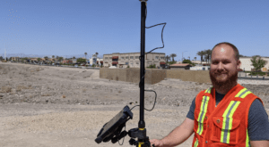
Real-Time Kinematic (RTK) is a buzz term in the UA industry, one many pilots may not understand, even though they may be “mapping” with an uncrewed aircraft (drone). When it comes to RTK and drone mapping, how necessary is the technology to a drone services provider? Will it earn …
Read More »
4:25 pm
commericial drone mapping, Drone, drone mapping, Drone News Feeds, DroneDeploy, mapping platform, News
First Annual DroneDeploy Social Impact Report by DRONELIFE Staff Writer Ian M. Crosby DroneDeploy, the leading enterprise-grade drone data company, has released its first ever Annual Social Impact Report, documenting the impact its social impact program has made over the course of 2021. Aiming to ensure that the company has …
Read More »
11:08 am
DL Exclusive, Drone, Drone Deploy, Drone Inspections, drone mapping, drone measuring, Drone News Feeds, Drones for residential solar, drones for roofing, Feature 1, News, sunrun
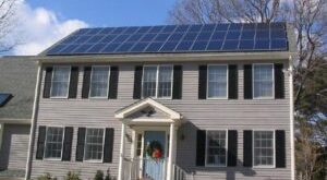
Gray Watson, CC BY-SA 3.0 Using drones for residential solar: DroneDeploy software allows Sunrun to conduct roof inspection without risk to workers By Jim Magill Drone technology is spurring the growth of another innovative industry, the residential solar power industry. Beginning in 2019, Sunrun, the leading home solar system installer …
Read More »
11:46 am
Applications, DL Exclusive, Drone, drone mapping, Drone News Feeds, DroneDeploy, ground mapping, mapping for construction, News, photogrammetry
DroneDeploy’s New Products: company launches mapping, inspection and ground-based robot products By Jim Magill Drone software company DroneDeploy unveiled a suite of new products, allowing customers to virtually walk through construction sites, capture and process data across miles of pipelines or electric transmission lines, and control walking inspection robots from …
Read More »